

Notice: This is the official website of the All Empires History Community (Reg. 10 Feb 2002)


Can you put maps about Kurds and Kurdistan ? |
Post Reply 
|
| Author |
 Printable Version Printable Version Google Google Delicious Delicious Digg Digg StumbleUpon StumbleUpon Windows Live Windows Live Yahoo Bookmarks Yahoo Bookmarks reddit reddit Facebook Facebook MySpace MySpace Newsvine Newsvine Furl Furl Topic Search Topic Search  Topic Options Topic Options
|
Kurdish_Fire 
Immortal Guard 

Joined: 20-Jun-2010 Online Status: Offline Posts: 7 |
 Quote Reply Quote Reply
 Topic: Can you put maps about Kurds and Kurdistan ? Topic: Can you put maps about Kurds and Kurdistan ?Posted: 28-Jun-2010 at 07:22 |
|
Hi Everybody I need some maps which can show place of Kurds and Kurdistan It doesn`t matter in which empire
|
|
|
The Death cannot scare us
|
|
 |
|
|
New Corduene
Janissary 

Joined: 05-Nov-2010 Online Status: Offline Posts: 26 |
Quote Reply
Posted: 06-Nov-2010 at 14:51 |
|
Yeah, sure;
 |
|
|
|
|
Altar
Janissary

Joined: 23-Sep-2010 Online Status: Offline Posts: 13 |
Quote Reply
Posted: 23-Feb-2011 at 16:37 |
|
a dream land :) which does not exist.... one day maybe ha? when the red snow falls :))))
|
|
|
|
|
Arab
Pretorian 
Joined: 09-Jul-2010 Online Status: Offline Posts: 197 |
Quote Reply
Posted: 25-Feb-2011 at 03:53 |
|
I remember you started a thread about this a while ago in which you posted these maps:
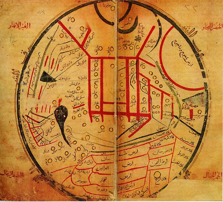  The first one was made by Mahmud al-Kashgari in 1074 and shows a place called "Ard el-Ekrad" which means "Land of the Kurds" in Arabic. The second is an Ottoman map from 1893 and shows a large area called Kurdistan.
I found this map from 1721 showing a place called "Curdistan".
 |
|
|
|
|
opuslola
Tsar 

suspended Joined: 23-Sep-2009 Location: Long Beach, MS, Online Status: Offline Posts: 4620 |
Quote Reply
Posted: 25-Feb-2011 at 20:20 |
|
Funny isn't it, just how many ways just one old place can be spelled? I have already proposed that the word "Kurd" is descriptive of the main diet of those people who inhabited the area! Perhaps, I should have written "Curd?" As in "Curds and Whey?"
Can you, for instance, show me that I am wrong? Regards, |
|
|
http://www.quotationspage.com/subjects/history/
|
|
|
|
|
MediaWarLord
Consul 
Joined: 28-Nov-2010 Online Status: Offline Posts: 354 |
Quote Reply
Posted: 26-Feb-2011 at 04:48 |
The ancient name for Kurdistan: Karduniash appeared more than 3,500 years ago, when the Hurrians ('Guti, Mitanni and Kassites' = ARYANS! ) gained control of all Mesopotamia (Babylon).
I think that the name 'Kurdistan' existed even before some genius people from the Mesopotamia introduced / invented the writing system!
Edited by MediaWarLord - 26-Feb-2011 at 04:52 |
|
|
|
|
MediaWarLord
Consul
Joined: 28-Nov-2010 Online Status: Offline Posts: 354 |
Quote Reply
Posted: 26-Feb-2011 at 05:03 |
|
The New Middle East
 Edited by MediaWarLord - 26-Feb-2011 at 05:06 |
|
|
|
|
Ollios
Chieftain 

Joined: 22-Feb-2011 Location: Diyar-ı Rum Online Status: Offline Posts: 1130 |
Quote Reply
Posted: 18-Oct-2011 at 14:44 |
 Please Attention Please Attention *Ignoration of Kurds entity in Anatolia is a sample of extreme Turkish nationalism *Try to show more huge Kurdistan and more Kurdish population than reality are also samples of extreme Kurdish nationalism.  Minorities want to be seen bigger, Majorities want to see them more smaller Minorities want to be seen bigger, Majorities want to see them more smallerexample map of extreme Kurdish nationalism; From Syrian Kurds conference in US Senate building  ------------------------------------------- about map issue Ottoman Kurdistan 1785  1787  Next maps show Kurdistan more clearly. However, Lake Van and close lands are also in Armenia too (West Armenia) and Today, Kurds'(Kurds of Turkey) symbolic capital Diyarbakır/Amed isn't in Ottoman Kurdistan Region 1794  1811  1812  1813  1823  1856 (Lake Van isn't in Kurdistan in this map)  same map, all Ottoman Empire 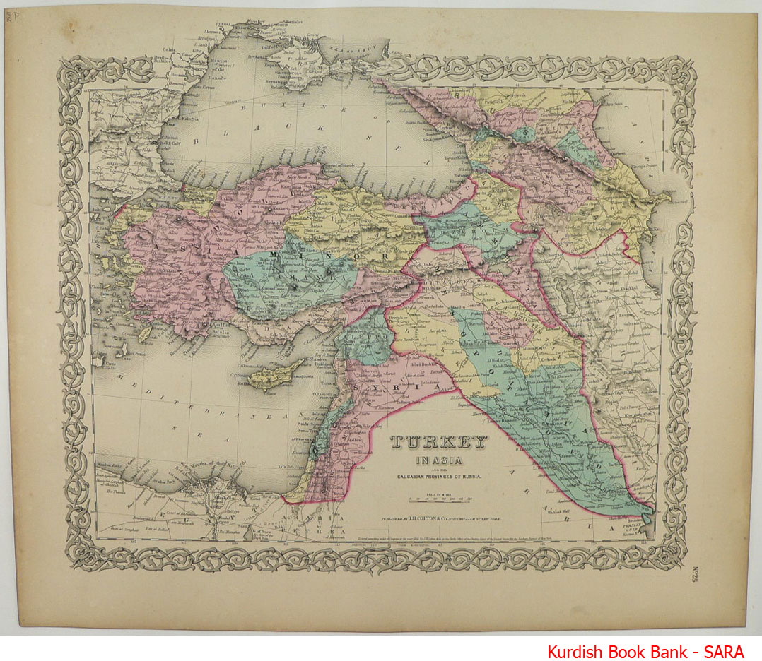 1916 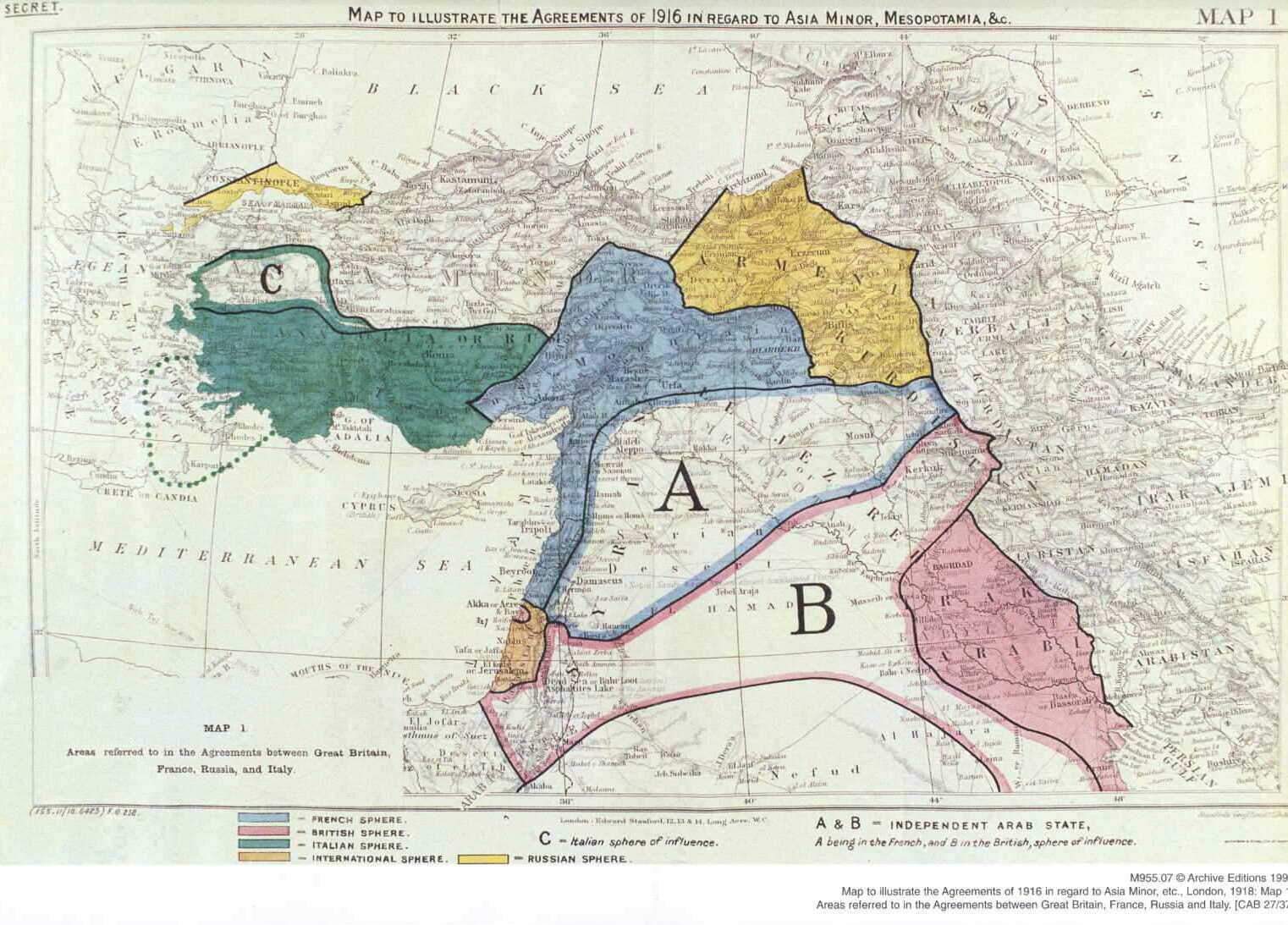 Modern Kurdistan According to USA military, but this map also shows bigger kurdistan than reality, Tabriz(Iran Azeris city) and Artvin(black sea cost) which is definately unrelated with Kurdish culture or historical Kurdistan are in Kurdistan)  one of the major factor of North Kurdistan/Turkish Kurdistan is Zaza people, are they Kurd or not? I know some Zaza who hate call as Kurd Political Maps about Kurds in Turkey The biggest map, general election 2002. darkgreen(I don't know how can I call that colour)-seperated dark green province is Zaza land. http://tr.wikipedia.org/wiki/Dosya:2002_T%C3%BCrkiye_genel_se%C3%A7im_sonu%C3%A7lar%C4%B1.svg Last election 2011-Zaza people not always have same political perspective(now they are red) with Kurds and also about north side of political kurdish movement is not located in always so north. Light green party is turkish nationalist party. http://tr.wikipedia.org/wiki/Dosya:2011_T%C3%BCrkiye_genel_se%C3%A7im_sonu%C3%A7lar%C4%B1.svg Edited by Ollios - 19-Oct-2011 at 09:57 |
|
|
Ellerin Kabe'si var,
Benim Kabem İnsandır |
|
|
|
|
Post Reply
|
| Forum Jump | Forum Permissions You cannot post new topics in this forum You cannot reply to topics in this forum You cannot delete your posts in this forum You cannot edit your posts in this forum You cannot create polls in this forum You cannot vote in polls in this forum |
Bulletin Board Software by Web Wiz Forums® version 9.56a [Free Express Edition]
Copyright ©2001-2009 Web Wiz
This page was generated in 0.074 seconds.
Copyright ©2001-2009 Web Wiz
This page was generated in 0.074 seconds.

