

Notice: This is the official website of the All Empires History Community (Reg. 10 Feb 2002)


Cool Historical Buildings |
Post Reply 
|
Page <12 |
| Author |
 Printable Version Printable Version Google Google Delicious Delicious Digg Digg StumbleUpon StumbleUpon Windows Live Windows Live Yahoo Bookmarks Yahoo Bookmarks reddit reddit Facebook Facebook MySpace MySpace Newsvine Newsvine Furl Furl Topic Search Topic Search  Topic Options Topic Options
|
Menumorut 
Chieftain 

Joined: 02-Jun-2006 Location: Romania Online Status: Offline Posts: 1423 |
 Quote Reply Quote Reply
 Topic: Cool Historical Buildings Topic: Cool Historical BuildingsPosted: 12-Feb-2007 at 20:41 |
|
These are the best examples of Merovingian architecture: The crypt of Jouarre Abbey The abbey was founded about 635 by Adon on private family lands. Adon was an officer in the court of Dagobert. The crypt served as a family burial site for the founders. 

See more at http://perso.orange.fr/abbayejouarre/Pages_simples/Table_des_matieres.htm The Saint Jean Baptistery in Poitiers It is the oldest Christian monument of France still in use. The central part was built arround 360. A baptismal bath was added in 6th century and a trandept in 6-7th century. 

See more: http://home.eckerd.edu/~oberhot/visitor-aquitaine.htm |
|
 |
|
 |
|
|
Menumorut
Chieftain
Joined: 02-Jun-2006 Location: Romania Online Status: Offline Posts: 1423 |
Quote Reply
Posted: 12-Feb-2007 at 20:54 |
|
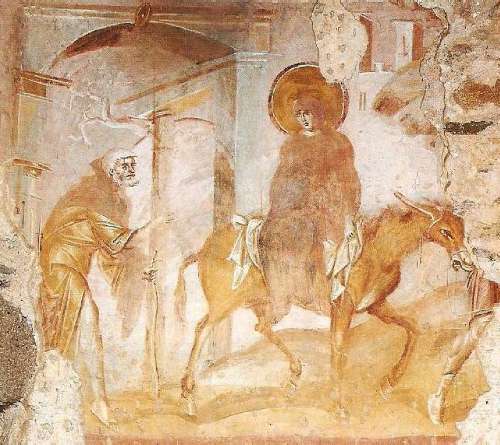
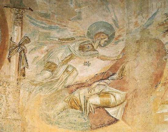
A misterious jewel of Italian art: Church of Church of Santa Maria foris portas, Castelseprio Castelseprio is the name of a comune in the Province of Varese in the Italian region Lombardy, located about 35 km northwest of Milan. It was once a Roman fort that commanded an important crossroad. It was also a major centre under the Lombards and a number of significant religious buildings from the first millennium survive. The whole area is now an archaeological zone containing the remains of the walls and of the much larger three-aisled 5th-century Basilica of San Giovanni Evangelista. There is also a baptistry of the 5th to 7th centuries dedicated to St. John the Baptist. This has two fonts, perhaps for the use of different Rites, and is octagonal with a small apse to the east. A third Church of San Paolo has a central hexagonal plan and was built between the 6th and 12th centuries. When the Church of Santa Maria foris portas was discovered in 1944, it was found to contain, as well as later frescoes, a highly important and sophisticated cycle of fresco paintings showing very strong Byzantine influence. The dating of the frescoes and the origin of their painter or painters remain controversial, although the first half of the 9th century seems to be emerging as the most likely date. 
|
|
|
|
|
|
|
|
Menumorut
Chieftain
Joined: 02-Jun-2006 Location: Romania Online Status: Offline Posts: 1423 |
Quote Reply
Posted: 12-Feb-2007 at 21:42 |
|
The Aurelian's Walls of Rome
The Aurelian Walls were city walls built between 270 and 273 in Rome during the reign of the Roman Emperor Aurelian. The 12.5-mile-long wall was intended to defend the city from barbarian attacks. At the time, the city had been grown well beyond the old Servian Wall, built during the late 4th century BC, and had been relatively safe during the centuries of Roman expansion and consolidation. However, by the 3rd century, the menace of barbarian tribes flooding through the Germanic frontier could not be easily stopped by the Roman Army, with the empire in a heavy crisis. More at http://www.geocities.com/mp_pollett/aurelinx.htm 

|
|
|
|
|
|
|
|
Menumorut
Chieftain
Joined: 02-Jun-2006 Location: Romania Online Status: Offline Posts: 1423 |
Quote Reply
Posted: 28-Feb-2007 at 12:14 |
|
Brasov/ Kronstadt city, Romania

|
|
|
|
|
|
|
|
ataman
Chieftain
Joined: 27-Feb-2006 Location: Poland Online Status: Offline Posts: 1108 |
Quote Reply
Posted: 01-Mar-2007 at 06:28 |
Hotin (Chocim in Polish) is also very important historical place for Poland. For a long time Dniestr was the border river between Poland (later Polish-Lithuanian Commonwealth) and Moldavia. There were a couple of battles at Chocim - including the biggest ones in 1621 and in 1673, where armies of PLC clashed againts armies of Ottoman Empire.
Below is another photo of Chocim castle (the guy on the photo is my friend Radosław Szleszyński; he is wearing hussar clothes and armour).
 But IMHO the coolest building is the basilic La Sagrada Familia in Barcelona (though I don't know if it can be called historical building
Edited by ataman - 01-Mar-2007 at 06:45 |
|
|
|
|
Menumorut
Chieftain
Joined: 02-Jun-2006 Location: Romania Online Status: Offline Posts: 1423 |
Quote Reply
Posted: 01-Mar-2007 at 18:59 |
Thanks for photo and information. |
|
|
|
|
|
|
|
Menumorut
Chieftain
Joined: 02-Jun-2006 Location: Romania Online Status: Offline Posts: 1423 |
Quote Reply
Posted: 23-Mar-2007 at 19:42 |
|
More photos from Orheiul Vechi, Republic of Moldova:
          
The archeological complex Old Orhei is situated in the valley of a right tributary of Dniestr � Raut River, between the villages Trebujeni and Butuceni, district of Orhei, 60 km North East from Chisinau. It is located in a well marked historic-geographical zone, famous and known among natives since ancient times as �Codrii Orheiului� or �Tara Orheiului� (Orhei land)- once forming a distinct territorial administrative body component of one of the many medieval Romanian countries in the immense Carpathian � Danubian space. As a result of archeological researches it was concluded that within the archeological complex of Old Orhei cultural layers from all known historic eras on the territory between the Dniestr and the Prut Rivers are clearly identified. These are: the Stone Age (30-20 thousand years BC), the Stone and Copper Age (iv-III millenium BC), the Bronze Age (II millenium BC) the transition to the Iron Age (XII-X centuries BC), the Early Iron Age (VIII-I centuries D), the late Ancient Period (III- IV centuries AD), the early Middle Ages (V-XIII centuries), and late Middle Ages (XIV-VXII centuries). Among these archeological vestiges could be mentioned at least 8 unfortified settlements (30-20 thousands years BC, IV-III mil. BC, II millenium BC, XII-X centuries BC, VIII-VI centuries BC, II-I centuries BC, III-IV centuries AD, V-XIII centuries AD); 5 necropolises (II-I centuries BC, X-XI centuries AD, XIV century, XV century, XVI century), 6 distinct fortified ground wall systems (IV-II centuries BC, and XIV-XVI centuries), a round and wood citadel (VI-III centuries BC), a ground citadel (XII-XIV centuries), a stone citadel (XIV-XVI centuries), and 2 old cities (Sehr al-Jedid, XIV century and Old Orhei XV-XVI centuries ). Also, 4 stone and ground fortresses should be mentioned on the adjacent promontories from the IV-III centuries BC (Trebujeni-Potarca, Trebujeni-Scoc, Trebujeni-Selitra, and Mascauti-Cetatuie). All of these together form the so-called archeological complex of Old Orhei. Monumental Buildings The Getic fortress The oldest fortified construction at the Old Orhei is the Getic fortress on the Butuceni promontory. The archeological excavations showed that there were people living on the top of the Butuceni hill starting with the VIII-VII centuries BC. In the V century BC the inhabitants fortified the establishment, later on brought changes to the defensive system. Traces of some fortifications found after the archeological excavations show us that at first the whole territory form the Raut�s curve had been fortified. In the narrowest point of the of the river�s curve the inhabitants made many ditches and ground walls next to them, beginning by the edge of the rock in the northern part and finishing at the Raut�s bank on the bed. The people from the fortress changed the highest part of the hill in a citadel protected from the north by the Raut�s rock, and from the other parts being surrounded by a beam, stone and ground palisade. The passage into the citadel was through a special gate in the eastern end of the citadel. Not to far from the gate, outside the citadel specialists have uncovered the ruins of a wall made of big blocks of local limestone. This wall originates from a huge gate built under the influence of the Greek fortresses on the Black Sea. The discovery of the traces of a religious building on the highest point of the citadel, in its center, next to the rocky bank of the Raut river is of great interest. The religious place at Butuceni was of round form and consists of a stone hearth surrounded by three rows of pillars. In the first circle of pylons there are holes, in the second - six, and in the third one � twelve. The archeological materials found on the sanctuary place are from the IV-III centuries BC. It is presumed that this building had the signification of a calendar. The Butuceni fortress was left at the end of the III century BD � beginning of the II century as a result of German and Baestarnae tribes� invasions. The inhabitants continued to activate within an unfortified settlement on the riverbank. Medieval Fortress At the beginning of the XIV century the Tatar-Mongolians had occupied the space between the Carpathians and the Dniestr. On the headland between the Trebujeni and Butuceni villages from the valley of the river, was built a new city � Sehr-al-Djedid (meaning New City) in the place of an old native settlement called Orhei (meaning fortification, reinforcement). Experts in all fields of urban household from the Crimea and other occupied centers were brought to the new establishment, with the main goal to redo the conquered �city� into a Oriental like center. At this point a grand building begun. The existing small ground and wood fortress was destroyed, and a new stone fortress was built in its place. The engineers and architects, involved in the building of the citadel, had to position it in the space between the rock and the central entrance road in the city. It also had to be squares, its entrance to the south. In the end, the fortress got a trapezoidal form with its sides of 127 meters, 121.9 meters, 107 meters and 92.5 meters. The citadel had a decorative bastion at each corner and two semicolons on the exterior side of the walls, forming the southwestern corner of the building. A great building annexed to the north wall was in the interior of the citadel. Having its entrance in the south, the building as the fortress had an irregular form and a winding plan. The building had 2 different sized rooms. In the center it had a spacious room with a underground burial vault. Some materials point out that the central room of the building was a mosque, with a basement and four lateral compartments located at each cardinal point. The other rooms were congregated around the mosque. The basement of the mosque was arranged as a tomb, in which an important person was buried. The tomb was lined with big stone blocks taken from another building�s wall. Some blocks had fashioned sides and decorated. A stone plate had an inscription with Arab ornament. The majority of the stone blocks came probably from a city mosque and from the gates of the courts of a nearby khan. After the city was freed of the Golden Horde occupation, the building inside the citadel became the residence of the magistrate of Orhei district. The entrance in the building was provided with a patio, it got the aspect of local Moldovan houses. The tomb was transformed in cellar, where food supplies were kept. Feredeu - The bathing rooms Federeu (baile publice)The archeologist Gheorghe Smirnov, the chief of the work site, and his colleagues after researches concluded that the discovered foundations on the riverbank, by the ford belong to a public bathing place in oriental style. The form of the building was a rectangular. The length was 40 meters and the width 23 meters. The walls were made form a craggy, little processed stone. Better processed were the door blocks. The bath had two sections, probably one for women, and another for men. The bathing rooms were of different sizes. All the rooms had aqueducts from clay pipes passing through the wall. The Khan The khan is a terrain of rectangular form with the dimensions of57.7x51.5 meters, and a surface of 1 861.55 square meters. A stone wall with a width of 1.3 meters surrounds it. The khan�s court is oriented from the north to south. The entrance is on the northern side. The church In 1950s Gheorghe Smirnov begun researching the churches foundations but the excavation reports were not preserved. The archeologists have pointed out the remnants of a church nearby the stone citadel. The church was made out of wood and it had burned. Very interesting is the fact that in this saint place between the years 1480-1484 pan Vlaicu Gales was buried. He was a cousin of Moldavia�s great king Stefan the Great and brother of the chief magistrate of Orhei district. Since the tombstone from the deceased Vlaicu was preserved, and experts decoded the inscription from it, it was possible to determine when the church was founded and who was its henefactor. Cave monasteries In the first centuries of the Christian era in the Carpahian-Dniestrian space the first Christian appeared. Among them were the acolytes of the Audias bishop, which in the IV century were expulsed by the Roman Emperor in Schitya Minor (nowadays Dobrogea). They went north from the Danube, where they founded many monasteries. Within these, according to Epifanios saying �the monastery rule flourished�. At the beginning of the Christ�s era on the cliff banks of Raut should had been many smaller and bigger caves, cut deep in the calcareous rocks by the natives (Gaeto-Dacians, Old Thracians or other pre-historic tribes). Looking for more efficient protection means in dangerous times, edifying a more perfect spirituality they penetrated �inside the rocks� in order to �become a rock� and to be closer to the divinity. The Christians from the 300-400 AD probably had used the existent at that point caves in Raut�s valley as those from other similar regions of the Middle Dniestre basin (Saharna, Tipova, Japca, Socola, etc.) working hardly to build new religious places. More info Edited by Menumorut - 23-Mar-2007 at 19:50 |
|
|
|
|
|
|
|
Post Reply
|
Page <12 |
| Forum Jump | Forum Permissions You cannot post new topics in this forum You cannot reply to topics in this forum You cannot delete your posts in this forum You cannot edit your posts in this forum You cannot create polls in this forum You cannot vote in polls in this forum |
Bulletin Board Software by Web Wiz Forums® version 9.56a [Free Express Edition]
Copyright ©2001-2009 Web Wiz
This page was generated in 0.063 seconds.
Copyright ©2001-2009 Web Wiz
This page was generated in 0.063 seconds.

