

Notice: This is the official website of the All Empires History Community (Reg. 10 Feb 2002)


Mesomearican Cities Photo Gallery |
Post Reply 
|
Page 12> |
| Author |
 Printable Version Printable Version Google Google Delicious Delicious Digg Digg StumbleUpon StumbleUpon Windows Live Windows Live Yahoo Bookmarks Yahoo Bookmarks reddit reddit Facebook Facebook MySpace MySpace Newsvine Newsvine Furl Furl Topic Search Topic Search  Topic Options Topic Options
|
|
Jalisco Lancer 
Sultan 
Retired AE Moderator Joined: 07-Aug-2004 Location: Mexico Online Status: Offline Posts: 2112 |
 Quote Reply Quote Reply
 Topic: Mesomearican Cities Photo Gallery Topic: Mesomearican Cities Photo GalleryPosted: 23-Aug-2005 at 12:59 |
|
|
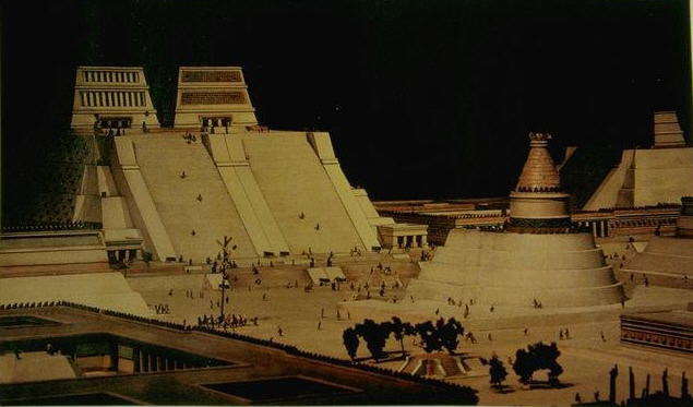
Teotihuacan ( City of the Gods )


Teotihuacan is a Nahuatl name, meaning Place where there is god-becoming. According to legend this was where the Gods gathered to plan the creation of man. The name Teotihuacan is also used to refer to the civilization this city dominated, which at its greatest extent included most of Mesoamerica. It is not known who these people were, but there is archaelogical evidence of having been a multi-ethnic place, with distinct Zapotec, Mixtec, Maya and what seems to be Nahua quarters, for example. The Totonacs have always maintained that they were the ones who built it, a story that was corroborated later by the Aztecs. The city was also anciently referred to as Tollan, a name also used centuries later for the Toltec capital of Tula (Tollan Xicocotitlan in Nahuatl). Construction of Teotihuacan commenced around 300 BC, with the Pyramid of the Sun built by 150 BC. The city reached its zenith approx. 150�450 AD, when it was the centre of an influential culture. At its height the city covered over 30km� (over 20 square miles), and probably housed a population of over 150,000 people, possibly as many as 200,000. Teotihuacan was an important source of obsidian and there was intensive trade with other regions of Mesoamerica. View of Avenue of the Dead from Pyramid of the MoonThe city's broad central avenue, called "Avenue of the Dead" (a translation from its Nahuatl name Micaohtli), is still flanked by impressive ceremonial architecture, including the immense Pyramid of the Sun and Pyramid of the Moon, the Temple of Quetzalcoatl, and many lesser temples and palaces. Unfortunately no ancient Teotihuacano texts are known to exist, but the city is occasionally referred to in the texts of Maya monuments, showing that Teotihuacan nobility traveled to and married with the families of local rulers as far away as Honduras. Maya hieroglyphs mention Spearthrower Owl, apparently Emperor of Teotihuacan, who reigned for over 60 years and imposed his relatives as kings of Tikal and Uaxactun in Guatemala. The city was sacked and burned, possibly by the invading Toltecs, sometime during the 7th or 8th centuries. Knowledge of the ruins of this huge city was never lost. The ruined city was a place of pilgrimage in Aztec times; it astonished visiting conquistadores; and it has been one of the most noted attractions for visitors to Mexico since the 19th century. Minor archeological excavations were conducted in the 19th century, and in 1905 major projects of excavation and restoration began under archeologist Leopoldo Batres, with the Pyramid of the Sun restored to celebrate the centennial of Mexican Independence in 1910. Teotihuacan remains a major tourist destination; it now contains a museum, and archeological excavations at the site are ongoing. Edited by Jalisco Lancer |
||
 |
||
|
Jalisco Lancer
Sultan
Retired AE Moderator Joined: 07-Aug-2004 Location: Mexico Online Status: Offline Posts: 2112 |
Quote Reply
Posted: 23-Aug-2005 at 13:11 |
|
|
Tenochtitlan


Tenochtitlan or, alternatively, Mexico-Tenochtitlan, was the capital of the Aztec empire, which was built on an island in Lake Texcoco in what is now central Mexico. The city was largely destroyed in the 1520s by Spanish conquistadores, Mexico City was erected on top of the ruins and, over the ensuing centuries, most of Lake Texcoco has gradually been drained. Many different tribes came and went from the shores of the lake without establishing a permanent, important culture. It was not until the arrival of the Aztecs, a tribe of people who came in from Aztl�n, a settlement from the deserts in Northern or Western Mexico of which no modern remains have been identified, that the area acquired its importance. The Aztecs migrated following an ancient legend that prophesied that they would find the site for their new city in a place where they would see a mythical vision fulfilled: an eagle eating a snake while perched atop a cactus. The Aztecs eventually came across this vision on what was then a small swampy island in Lake Texcoco, and the vision is now immortalized in Mexico's coat of arms, which is shown in the Mexican flag. Not deterred by the unfavourable terrain, they invented the chinampa system to dry the land by setting up small plots in which they produced all the food they required. When enough land was dry they would begin to build there. Tenochtitlan (the Nahuatl language name for the city) was founded in 1325. A thriving culture developed, and the Aztec empire came to dominate other tribes all around Mexico. The small natural island was perpetually enlarged as an artificial island as Tenochtitlan grew to become the largest and most powerful city in Mesoamerica. Commercial routes were developed that brought goods from places as far as the Gulf of Mexico, the Pacific Ocean and perhaps even the Inca Empire. The city was connected to the mainland by a series of wide causeways with bridges. The city was interlaced with a series of canals, so that all sections of the city could be visited either on foot or via canoe. After a flood of Lake Texcoco, the city was rebuilt in a style that made it one of the grandest ever in Mesoamerica under Emperor Auitzotl. Spanish conquistador Hern�n Cort�s arrived in Tenochtitlan on November 8, 1519. At this time it is believed that the city was amongst the largest in the world alongside Paris and Constantinople. The most common estimates put the population at around 200,000 to 300,000 people. Aztec ruler Moctezuma II, thinking Cort�s to be the returning god Quetzalcoatl, welcomed him with great pomp. Some of the conquistadores had traveled as widely as Venice and Constantinople, and many said that Tenochtitlan was as large and fine a city as any they had seen. Cort�s and his men, aided by local tribes, eventually conquered the city on August 13, 1521, after a struggle that lasted months in which much of the city was destroyed. The rest of the city was either destroyed, dismantled or buried as Mexico City was built on top of it. For the later history of this city, see: History of Mexico City  Edited by Jalisco Lancer |
||
|
||
|
Jalisco Lancer
Sultan
Retired AE Moderator Joined: 07-Aug-2004 Location: Mexico Online Status: Offline Posts: 2112 |
Quote Reply
Posted: 23-Aug-2005 at 14:42 |
|
|
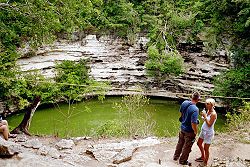
Chichen Itza 


The name is often represented as Chich�n Itz� in Spanish and other languages to show that both parts of the name are stressed on their final syllables. In the Yucatec Maya language (still in use in the area, and written with the Roman alphabet since the 16th century) this stress follows the rules of the language so it is written without diacritics. The Maya name "Chichen Itza" means "At the mouth of the wells of the Itza people". Although this was the usual name for the site in Pre-Columbian times, it is also referred to in the ancient chronicles as Uucyabnal, meaning "Seven Great Rulers". [Sacred Cenote"Chichen" contains many fine stone buildings in various states of preservation; the buildings were formerly used as temples, palaces, stages, markets, baths, and ballcourts. The Yucat�n has no above-ground rivers, so the fact that there were three natural sink holes (cenotes) providing plentiful water year round at Chichen made it a natural spot for a center of population. Two of these cenotes are still in existence, the most famous being the legendary "Cenote of Sacrifice", which was sacred to the Maya rain god Chac. Offerings of jade, pottery, and incense were thrown into the great well as offerings to Chac, and occasionally during times of desperate drought a human sacrifice -- however there is no confirmation in either ancient chronicles nor the archeological dredging of the cenote to confirm the lurid tales of some tour guides claiming that great numbers of beautiful, young, virgin women were regularly cast into the well. The Sacred Cenote was long a place of pilgrimage Yucat�n. Chichen was a major center by about 600 in the middle of the Maya Classic period, but the city saw its greatest growth and power after the Maya sites of the central lowlands to the south had already collapsed. Some of the notable classic era structures at Chichen include a fine complex of buildings in the "Puuc" architectural style. The Spanish nicknamed this complex "Las Monjas" or "The Nunnery" but was actually the city's classic era government palace. Just to the east is a small temple (nicknamed "La Iglesia", "The Church") with decorated with elaborate masks of the rain god. To the north is a round building on a large square platform nicknamed "El Caracol" or "the snail" for the stone spiral staircase inside; this was an observatory (the doors were alligned to view the vernal equinox, the Moon's greatest northern and southern declinations, and other astronomical events) sacred to Kukulcan, the feathered-serpent god of the wind and learning. Apparently about 987 a Toltec king named Quetzalcoatl arrived here with an army from central Mexico, and (with local Maya allies) made Chich�n Itz� his capital, and a second Tula. The art and architecture from this period shows an interesting mix of Maya and Toltec styles. Chichen's "Temple of the Warriors" was clearly built as a copy of Temple B at the Toltec capital of Tula, although thanks to the Maya architects is grander than the original. This is a stone building (originally with a wood and plaster roof) atop a step-pyramid, with the columns in the interior carved with the likenesses of warriors. At the top of the stairway leading to the entrance of the temple is a type of altar-statue known as a Chac Mool. Dominating the center of Chich�n is the Temple of Kukulcan (the Maya name for Quetzalcoatl), often referred to as "El Castillo" (the castle). This step pyramid with a ground plan of square terraces with stairways up each of the 4 sides to the temple on top. Great sculptures of Plumed Serpents run down the sides of the northern staircase, and are set off by shadows from the corner tiers on the Spring and Fall equinox. It was practice in Mesoamerican cities to periodically build larger and grander temple pyramids atop older ones, and this is one such example. Thanks to archeologists, a doorway at the base of the north stairway leads to a tunnel, from which one can climb the steps of the earlier version of El Castillo inside the current one, up to the room on the top where you can see King Kukulcan's Jaguar Throne, carved of stone and painted red with jade spots. Seven courts for playing the Mesoamerican ballgame have been found in Chich�n, but the one about 150 meters to the north-west of the Castillo is by far the most impressive. It is the largest ballcourt in ancient Mesoamerica. It measures 166 by 68 meters (545 by 232 feet). The sides of the interior of the ballcourt are lined with sculpted panels depicting teams of ball players, with the captain of the winning team decapitating the captain of the losers. Built into one of the exterior walls of the ballcourt is the Temple of the Jaguar, which features another jaguar throne -- since this one was not buried for a thousand years, its red paint and jade spots are long since gone. Chichen Itza also has a variety of other structures densely packed in the ceremonial center of about 5 km� (2 mile�) and several outlying subsidiary sites. Nearby are the sacred Caves of Balankanche, where a large selection of ancient pottery and idols may be seen still in the positions where they were left in Pre-Columbian times. The Maya chronicles record that in 1221 a revolt and civil war broke out, and archeological evidence confirms that the wooden roofs of the great market and the Temple of the Warriors were burnt at about this date. Chichen Itza went into decline as rulership over Yucat�n shifted to Mayapan. While the site was never completely abandoned, the population declined and no major new constructions were built. The Sacred Cenote, however, remained a place of pilgrimage. In 1531 Spanish Conquistador Francisco de Montejo claimed Chich�n Itz� and intended to make it the capital of Spanish Yucat�n, but after a few months a native Maya revolt drove Montejo and his forces from the land. In 1839 United States travel writers Benjamin Norman, followed the next year by John Lloyd Stephens, visited and published accounts of the ruins of Chichen Itza. Various other expeditions made further examinations of the ruins in the following decades. In 1901 the United States Consul to Yucat�n, Edward H. Thompson bought Chichen Itza (as the ruins had no protected status then) and moved there with his Maya wife, and spent some 30 years doing amateur archeology there, including dredging the first artifacts out of the Sacred Cenote. In 1924 the Carnegie Institution and Harvard University began a 20 year excavation project directed by Sylvanus G. Morley, which included restoring two sides of the Castillo. In 1961 the Sacred Cenote was dredged more thoroughly by Mexico's National Institute of Anthropology and History (INAH). In the 1980s INAH excavated some additional buildings and restored the other two sides of the Castillo. Chichen Itza is today a World Heritage Site and is a very popular tourist destination; it is the most visited of the major Maya archaelogical sites. Many visitors to the popular tourist resort of Canc�n make a day trip to Chichen Itza, usually with time to view only a portion of the site. 


|
||
|
||
|
Jalisco Lancer
Sultan
Retired AE Moderator Joined: 07-Aug-2004 Location: Mexico Online Status: Offline Posts: 2112 |
Quote Reply
Posted: 23-Aug-2005 at 17:05 |
|
|
Tulum City of the Dawn 


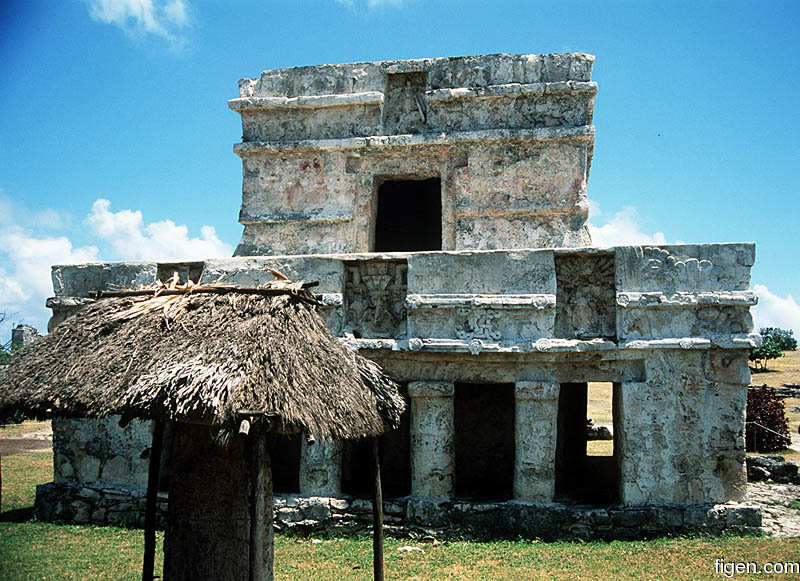

Tulum was once called Zama, meaning �place of the dawning sun�. How it got this name is obvious as this ancient Mayan city is situated on a cliff which faces east toward the beautiful turquoise waters of the life-giving Caribbean. This is surely one of the most scenically beautiful of all the Mayan archeological sites. Tulum was a site of main importance between 1,000-1,600. This was a place for the elite of the Maya world. At first glimpse one might mistake Tulum for an ancient country club, with its beautiful grounds and sweeping views of the sea. If one explores deeper, however, this illusion is disturbed by the presence of a large twenty foot wall that surrounds the site which bespeaks of the need for defense against invaders from both land and the sea. Tulum was one of the first cities that the Spanish Conquistadors encountered in Mexico. It was the only Mayan city still thriving that they found. Intimidated by its size and grandeur they didn�t stay to visit. A wise decision as the residents of Tulum are known for a tradition of rebellion that lasted for several centuries, never falling to Spanish rule. They eventually abandoned the city but not until almost a century after the Spanish conquest. During the War of the Castes in the 19th century, it became a major center of resistance to Mexican rule. Tulum didn�t sign a treaty with the Mexican government until 1935. Tulum has a number of interesting structures from the ancient Mayan world. Graceful columns and elegant carvings give one an appreciation for the architectural achievements of the Maya. Some of its main archeological features are the Temple of the Frescoes, the Castillo pyramid and the Temple of the Diving God. Unique corner masks grace the outside of the Temple of the Frescoes. Inside are fantastic 13th century murals depicting ancient ceremonies. One of the few surviving images of the Mayan goddess of fertility and medicine, Ixchel, can be found here. Red paint still clings to the stucco on the outside of the temple. It is believed that at one time all the buildings in Tulum were painted red. The Castillo is known more for its scenic location than its size. Although its front facade has all the features of other Mayan temples, its back side seems more like a fortress. Small windows face out toward the sea, providing an excellent lookout post from which to watch for sea faring invaders. Visitors feel compelled to photograph this impressive structure standing regally against a backdrop of the beautiful Caribbean. The Temple of the Diving God is so named because it has an unusual figure above the doorway that appears to be diving headfirst to earth. There are many theories about the meaning of these curious carvings which also appear at the Mayan site of Coba but few other sites. They have also been called �the bee god� or �the god descending� and have been associated with the planet Venus. It is a popular symbolic motif in the temple doorways at Tulum which contain several of these unique figures. |
||
|
||
|
Jalisco Lancer
Sultan
Retired AE Moderator Joined: 07-Aug-2004 Location: Mexico Online Status: Offline Posts: 2112 |
Quote Reply
Posted: 23-Aug-2005 at 17:12 |
|
|
TzinTzunTzan ( Place of the Hommingbird ) 


Tzintzuntzan is a city in the state of Michoac�n, Mexico, located at 19�37′ N 101�35′ W. Tzintzuntzan stands on the eastern shore of Lake P�tzcuaro, about 15 km north of the city of P�tzcuaro and about 60 km west of state capital Morelia, and at some 2050 m above sea level. It serves as the administrative seat for the surrounding municipality of the same name and, in the 2000 census, reported a population of 3,610 people. The city was founded in the 13th century by the Native American Tarascan or Purepecha nation, in whose language the name means "Place of the Hummingbirds". In the last years of the 15th century it became the capital of the Tarascan league, replacing nearby Ihuatzio. During this time the Purepecha successfully repulsed an invasion by the Aztecs. The Pre-Columbian city of Tzintzuntzan covered an area of about 7 km�. The site, which stands on a hillside above the modern town, has the remains of many step pyramids of a design typically used by the Purepecha in their ritual buildings, known locally as y�catas (by extension, the present-day archeological site is also known as "Las Y�catas"). The Tzintzuntzan y�catas are of several different shapes, some rectangular, some oval or circular, and others in the distinctive Tarascan "T" shape. The population of the ancient city is estimated to have peaked at somewhere between 25,000 to 35,000 people. Tzintzuntzan was still the Tarascan capital when the Spaniards arrived in 1522. First contact, led by Crist�bal de Olid, was peaceful, but when a second Spanish expedition led by Nu�o de Guzm�n arrived in 1529, Chieftain Tanganxoan was burned alive and the city largely dismantled to provide stones for Roman Catholic temples and civic buildings, most notably the large 16th century Franciscan Monastery of Santa Ana. Following the disgrace and recall of Nu�o de Guzm�n, Vasco de Quiroga was sent to the region, and Tzintzuntzan served as the headquarters of Spanish power in the area until the bishopric was relocated to P�tzcuaro in 1540. The modern town of Tzintzuntzan is known for the basketry and weaving produced there. The Monastery of Santa Ana is also still standing. It is home to several allegedly miraculous relics and icons and is reputed to have growing in its grounds what were the first olive trees to be planted in America. 
|
||
|
||
|
Jalisco Lancer
Sultan
Retired AE Moderator Joined: 07-Aug-2004 Location: Mexico Online Status: Offline Posts: 2112 |
Quote Reply
Posted: 23-Aug-2005 at 17:18 |
|
|
Monte Alban ( Sacred Mountain )


Monte Alb�n is a large archeological site in the state of Oaxaca, Mexico. The name "Monte Alb�n" means "White Mountain" in the Spanish language; the Zapotec name was Danipaguache, meaning "Sacred Mountain". The Aztecs knew it as Ocelotepec, or "Jaguar Mountain". This sacred Mesoamerican city is on an artificially flattened mountain top some 400 meters above the city of Oaxaca. Monte Alb�n was built over a period of over 2,000 years, starting about 900 BC, by the Zapotec people. The early art shows Olmec influence. The most impressive building period was during the Mesoamerican Classic era, from about 550 to 1000. About 1300 the Zapotec were driven out of the site and surrounding area when was conquered by the Mixtec people. The Mixtec made further additions to Monte Alb�n until they in turn were conquered by the Spanish Conquistadores in 1521, at which time Monte Alb�n was abandoned. Guillermo Dupaix investigated the site in the early 19th century. J. M. Garc�a published an account of the site in 1859. A. F. Bandelier visited and published further descriptions in the 1890s. The first large-scale archaeological project of the site was done in 1902 by Leopoldo Batres. Eighteen years of more extensive excavations began in 1931 under Alfonso Caso. Despite such detailed work, much of the large site, over 80%, has never been excavated. [edit] Monuments Monte Alb�n has many step-pyramids, temples, elite tombs, and a court for playing the Mesoamerican ballgame. There are also free-standing sculptured stelae, and large bas-relief carved panels in some of the buildings. The oldest carved stones at the site are the so-called "Danzantes" (literally, dancers), featuring drawings of people in contorted and twisted poses. Although the notion that they depict a dance is generally discredited now, there is still little agreement on what exactly the figures represent. Some of the original stones can be viewed in the museum at the site. Building J (the arrowhead-shaped building shown in the top picture) has also invited much speculation, due to its unusual shape and orientation. Caso suggested it was an astrological observatory, though other theories have been offered. The building also features large carved slabs depicting upside-down heads, which Caro called "conquest slabs" depicting vanquished enemies. |
||
|
||
|
eaglecap
Tsar 

Retired AE Moderator Joined: 15-Feb-2005 Location: ArizonaUSA Online Status: Offline Posts: 3959 |
Quote Reply
Posted: 23-Aug-2005 at 17:20 |
|
|
very interesting! I will show this to little Brittany to show her the other half of her heritage. She wants to be a Doctor now but you know how many times kids change their minds.
I know some of the tribes in California and some other western states spoke a branch of the Azteca language while the Navajo spoke Hokan, which they claim is older. I would like to find out what language group the Iriquois Indians spoke since I have Iriquois ancestry. Any ideas?? |
||
|
Λοιπόν, αδελφοί και οι συμπολίτες και οι στρατιώτες, να θυμάστε αυτό ώστε μνημόσυνο σας, φήμη και ελευθερία σας θα ε
|
||
|
||
|
Jalisco Lancer
Sultan
Retired AE Moderator Joined: 07-Aug-2004 Location: Mexico Online Status: Offline Posts: 2112 |
Quote Reply
Posted: 23-Aug-2005 at 17:24 |
|
|
Tajin ( City of the Thunder ) El Taj�n is a Pre-Columbian archaeological site near the city of Papantla, in the state of Veracruz, Mexico. Pyramid of the Niches before restoration; 1913 photoThe city El Taj�n was the capital of the Totonac state. Taj�n means city or place of thunder in the Totonac language, and is believed to have been one of the names for the Totonac god of thunder, lightning and rain. History of El Taj�n Construction of ceremonial buildings at El Taj�n began about the 1st century. Early classic Taj�n shows influence of Teotihuacan; early postclassic shows considerable Toltec influence. Construction continued to about the start of the 13th century, at which time the city was conquered and burned by Chichimec invaders. The site continued to be occupied after this by a smaller population, but no new large construction projects were initiated. The site was completely abandoned with the arrival of the Spanish conquerors in the early 16th century. The abandoned site was overgrown with forest. In 1785 engineer Diego Ruiz visited the site and published the first description of the site. In the early 19th century it was visited by Guillermo Dupaix, Alexander von Humboldt, and Carlos Nebel, who published additional accounts. The first archeological excavation of the site was made by Jose Garcia Payon from 1943 through 1963. The Mexican Institute of Anthropology & History has made additional restoration to buildings at the site since the 1980s. [edit] Monuments The ceremonial center of the site is covers only about 1 km square, but there are mostly unexcavated remains of subsidiary buildings extending for a considerable distance beyond. The ceremonial center has number of temple-pyramids, palaces, and several courts for playing the Mesoamerican ballgame. The site's most famous building is the Pyramid of the Niches. The step pyramid of 6 terraces is some 60 feet high. The size is only medium as Mesoamerican pyramids go, but the architecture is creates a striking and visually pleasing effect. The terraces are of well cut stone froming a series of 365 niches. A staircase rises up the pyramid's east side. Originally the pyramid was topped by a temple, but little remains of this. A number of the buildings have carved relief on them, and the site also has some free standing stone stelae. Many of the sculptures depict the ritual ballgame and rituals bloodletting by the elite. The site is now a tourism destination, has a moderate sized museum. Source: http://en.wikipedia.org/wiki/El_Taj%C3%ADn" 


.jpg)


|
||
|
||
|
Jalisco Lancer
Sultan
Retired AE Moderator Joined: 07-Aug-2004 Location: Mexico Online Status: Offline Posts: 2112 |
Quote Reply
Posted: 23-Aug-2005 at 17:33 |
|
|
Mitla ( Place of the Dead ). From Wikipedia, the free encyclopedia. Mitla is a town in the state of Oaxaca, Mexico, famous for its pre-Columbian Mesoamerican buildings. The name Mitla or Mictlan is of Nahuatl origin and means "Place of the Dead" or "Inframundo". In Zapotec it is called "Lyobaa", which means "Burial Place", and in Mexico it became known as Mictlan, "Place of the Dead" which is shortened in Spanish to Mitla. The archaeological site and town itself are Zapotec. Mitla was inhabited in the Classic Period (100-650 DC), with its greatest growth and height in the Post Classic period (750-1521 DC). The town of Mitla The official name of the town is San Pablo Villa de Mitla. It had a population of just over 7,000 people in 1990. It is located about 45 km (some 26 miles) by road from the state capital of Oaxaca, Oaxaca, at 16��55�� N 96��24�� W. The main group of pre-Hispanic buildings is at the north end of town. The town of Mitla also has a small museum. Mitla hosts a large outdoor market. Grupo de las Columnas While archeological evidence shows that Mitla was occupied by 500 BC, the earliest construction dates to about 200 AD. Construction of Pre-Columbian style buildings continued up until the arrival of the Spanish Conquistadores in the 1520s. The town has been continually occupied ever since; part of the more recent town was built over pre-Hispanic Mitla, but some groups of old elite palace complexes remained. The earliest structures at Mitla are Zapotec; the remainder are Mixtec but often display an interesting mix of Zapotec and Mixtec styles. The most famous buildings are decorated with stones cut in repeating gemetric patterns. In 1494 the Aztecs conquered Mitla and sacked the city. A number of Spanish writers of the colonial era remark on the well built pre-Hispanic buildings here. Alexander von Humboldt published a description of the site in 1810. Some excavations and repair of buildings was done under the direction of Leopoldo Batres in 1901. The Mexican government made further excavations of the site in the mid 1930s and the early 1960s. 


|
||
|
||
|
Jalisco Lancer
Sultan
Retired AE Moderator Joined: 07-Aug-2004 Location: Mexico Online Status: Offline Posts: 2112 |
Quote Reply
Posted: 23-Aug-2005 at 17:39 |
|
|
Uxmal ( Built Three Times ) 


Uxmal is a large Pre-Columbian ruined city of the Maya civilization in the state of Yucat�n, Mexico. It is 78 km south of M�rida, Yucat�n, or 110 km from that city on Highway 261 towards Campeche, Campeche), 15 km south-southeast of the town of Muna. Uxmal is pronounced "Oosh-mahl". The place name is Pre-Columbian and it is usually assumed to be an archaic Maya language phrase meaning "Built Three Times", although some scholars of the Maya language dispute this derivation. Ancient history While much work has been done at the popular tourist destination of Uxmal to consolidate and restore buildings, little in the way of serious archeological excavation and research has been done here, therefore the city's dates of occupation are unknown and the estimated population (about 25,000 people) is at present only a very rough guess subject to change upon better data. Most of the architecture visible today was built between about 700 and 1100. Maya chronicles say that Uxmal was founded about 500 by Hun Uitzil Chac Tutul Xiu. For generations Uxmal was ruled over by the Xiu family, was the most powerful site in western Yucatan, and for a while in alliance with Chichen Itza dominated all of the northern Maya area. Sometime after about 1200 no new major construction seems to have been made at Uxmal, possibly related to the fall of Uxmal's ally Chichen Itza and the shift of power in Yucatan to Mayapan. The Xiu moved their capital to Man�, and the population of Uxmal declined. After the Spanish conquest of Yucat�n (in which the Xiu allied themselves with the Spanish), early colonial documents suggest that Uxmal was still an inhabited place of some importance into the 1550s, but no Spanish town was built here and Uxmal was soon after largely abandoned. Description of the site Even before the restoration work Uxmal was in better condition than many other Maya sites thanks to being unusually well built. Much was built with well cut stones not relying on plaster to hold the building together. The Maya architecture here is considered matched only by that of Palenque in elegance and beauty. The Puuc style of Maya architecture predominates. Thanks to its good state of preservation, it is one of the few Maya cities where the casual visitor can get a good idea of how the entire ceremonial center looked in ancient times. Some of the more noteworthy buildings include: The Governor's Palace, a long low building atop a huge platform, with the longest fa�ades in Pre-Columbian Mesoamerica. The Adivino or "Pyramid of the Magician", a fine pyramid temple unusual in several ways. The layers of the step pyramid are oval, rather than the usual rectangular or square shape. It was a common practice in Mesoamerica to build new temple pyramids atop older ones, but here a newer pyramid was built centered slightly to the east of the older pyramid, so that on the west side the temple atop the old pyramid is preserved, with the newer temple above it. The Nunnery Quadrangle (a nickname given to it by the Spanish; it was a government palace) is the finest of Uxmal's several fine quadrangles of long buildings with elaborately carved fa�ades on both the inside and outside faces A large Ballcourt for playing the Mesoamerican ballgame, which an inscription there informs us was dedicated in 901 by Chan Chak K'ak'nal-Ahau. the Nunnery Quadrangle at UxmalA number of others temple-pyramids, quadrangles, and other monuments, some of significant size, and in varying states of preservation, are also at Uxmal. The majority of hieroglyphic inscriptions were on a series of stone stelae unusually grouped together on a single platform. The stelae depict the ancient rulers of the city, and they show signs that they were deliberately broken and toppled in antiquity; some were re-erected and repaired. A further suggestion of possible war or battle is found in the remains of a wall which encircled most of the central ceremonial center. A large raised stone pedestrian causeway links Uxmal with the site of Kabah, some 18 km to the south. Detail of "Nunnery Quadrangle" fascade as drawn by Catherwood[edit] Modern history of the ruins The site, located not far from M�rida beside a road to Campeche, has attracted many visitors since the time of Mexico's independence. The first detailed account of the ruins was published by Jean Frederic Waldeck in 1838. John Lloyd Stephens and Frederick Catherwood made two extended visits to Uxmal in the early 1840s, with architect/draftsman Catherwood reportedly making so many plans and drawings that they could be used to construct a duplicate of the ancient city (unfortunately most of the drawings are lost). D�sir� Charnay took a series of photographs of Uxmal in 1860. Some three years later Empress Carlota of Mexico visited Uxmal; in preparation for her visit local authorities had some statues and architectural elements depicting phallic themes removed from the ancient fa�ades. Sylvanus G. Morley made a map of the site in 1909 which included some previously overlooked buildings. The Mexican' governments first project to consolidate some of the structures from risk of collapse or further decay came in 1927. In 1930 Frans Blom led a Tulane University expedition to the site which included making plaster casts of the fa�ades of the "Nunnery Quadrangle"; using these casts a replica of the Quadrangle was constructed and displayed at the 1933 World's Fair in Chicago, Illinois. In 1936 a further Mexican government repair and consolidation program was begun under Jos� Erosa Peniche. Queen Elizabeth II of the United Kingdom visited on 27 February of 1975 for the inaguration of the site's sound & light show; when the presentation reached the point where the sound system played the Maya prayer to Chac, a sudden torrential downpour fell upon the gathered dignitaries, despite the fact that it was the middle of the dry season. |
||
|
||
|
Jalisco Lancer
Sultan
Retired AE Moderator Joined: 07-Aug-2004 Location: Mexico Online Status: Offline Posts: 2112 |
Quote Reply
Posted: 23-Aug-2005 at 17:45 |
|
|
La Venta is the name of a Pre-Columbian archaeological site of the Olmec civilization. The site is located in the state of Tabasco, Mexico. The Olmec civilization was prominent in Mesoamerica from as early as 1500 B.C. up through A.D. 1. The Olmec heartland, an area on the Gulf of Mexico coastal plain of southern Veracruz and Tabasco, is thus called because of the concentration of a large number of Olmec monuments as well as the greatest Olmec sites. The area is about 125 miles long and 50 miles wide (200 by 80 km), with the Coatzalcoalcos River system running through the middle. These sites include San Lorenzo, La Venta, and Tres Zapotes. La Venta is one of the greatest of the Olmec sites. La Venta is dated to between 1200-400 B.C, which places the major development of the city in the Middle Formative Period. Located on an island in a coastal swamp overlooking the then-active R�o Palma river, the city of La Venta probably controlled a region between the Mezcalapa and Coatzacoalcos rivers. La Venta was found and excavated by Matthew Stirling between 1941 and 1943, with several subsequent excavations following through the 1960s. Stirling is sometimes credited with identifying the Olmec civilization; although some Olmec sites and monuments had been known earlier, it was Stirling's work that put the Olmec culture into context. The site itself is about 18 miles inland with the island consisting of slightly more than 2 square miles of dry land. The main part of the site is a complex of clay constructions stretched out for 12 miles in a North-South direction, although the site is 8� West of true North. The entire southern end of the site is covered by a petroleum refinery, and has been largely demolished, making excavations difficult or impossible. Many of the site's monuments are now on display in the archeological museum and park in the city of Villahermosa, Tabasco. In its heyday, La Venta was a monumental center that contained an elaborate series of buried offerings and tombs as well as monumental sculptures similar to the many found at San Lorenzo, perhaps the most well known of the Olmec sites. Power of the Olmec culture passed down to La Venta after the downfall of San Lorenzo, in about 900 B.C. It is calculated that the site supported a population of at least 18,000 people during its principal occupation. Among the major features of the site at La Venta are Complex A and the Great Pyramid. The Great Pyramid is a huge clay pyramid 110 ft high, one of the earliest pyramids known in Mesoamerica. The current conical shape of the pyramid was once thought to represent nearby volcanoes or mountains, but recent work by Rebecca Gonzalez-Lauck has shown that the pyramid was in fact a rectangular pyramid with stepped sides and inset corners, and the current shape is probably due to 2500 years of erosion. The pyramid itself has never been excavated, but is thought to contain an elaborate tomb, such as many other Mesoamerican mounds and pyramids do. Complex A is a mound and plaza group located just to the North of the Great Pyramid. It was erected in a period of 4 construction phases that span over a period of 4 centuries. Beneath the mounds and plazas were found a vast array of offerings and other buried objects including: buried jade celts, polished mirrors made of iron-ores, large mosaic offerings made of serpentine blocks, and perhaps the most unusual offering being 3 large pits, or Massive Offerings, filled with hundreds of tons of serpentine blocks. Of the buried offerings the most interesting were 4 rectangular pavements each about 15 ft � 20 ft and each consisting of about 485 blocks of serpentine. The mosaics were laid in the form of an abstract jaguar mask, a common theme in Olmec art. Perhaps the strangest part of the pavements is that they were covered over with many feet of clay and adobe layers soon after completion. It is clear that the Olmecs were a knowledgeable and artistic people, as is evident by the many monuments and sculptures they have left behind. The site of La Venta itself included floors of different colored clays and platforms painted in red, yellow, and purple. Throughout this city of color were a large number of monuments sculptured from basalt. Perhaps the most intriguing of the monuments are the four colossal heads. There are 14 known colossal heads at sites in the Olmec heartland, including San Lorenzo, La Venta, and Tres Zapotes. The site of La Venta contained 4 of these colossal heads. Olmec stone head, La VentaThe La Venta heads are thought to have been carved by 700 B.C., but possibly as early as 850 B.C, while the San Lorenzo heads are credited to an earlier period. The colossal heads can measure up to 9 ft 4 in. in height and weigh several tons. The sheer size of the stones causes a great deal of speculation on how the Olmecs moved the stones, because the nearest quarry for basalt was over 30 km away from San Lorenzo, where 8 heads are located. It is believed that the heads are portraits of mighty Olmec rulers, which are flat-faced, with thick-lipped features. These characteristics have caused much debate about the Olmecs and the resemblance of the heads to African characteristics. Some insist that the Olmecs were African. Others have said it is possible that the heads were carved this way reflecting the shallow space allowed on the basalt boulders, and not the actual appearance of the people. Others note that in addition to the broad noses and thick lips, the heads have the asian eye-fold, and that all these characteristics are still found in modern Mesoamerican indians. In the 1940s artist/art historian Miguel Covarrubias published a series of photos of Olmec artworks and of the faces of modern Mexican indians with very similar facial characteristics. Each of the heads wears headgear resembling football helmets, although each is unique in its decoration. These helmets probably served as protection in war and in the ceremonial Mesoamerican ballgame played throughout Mesoamerica. The site also included several "altars" of basalt, the most familiar being Altar 4. Altar 4 represents a figure, probably a ruler or shaman dressed in an elaborate headdress and sitting inside what appears to be a cave. The figure is holding on to a rope, which wraps around the base of the altar to the right side where it is tied to a seated figure. The left side is eroded away but is thought to be similar to the scene on the right. These "altars" have now been identified as thrones, which the Olmec rulers may have been seated on during important rituals or ceremonies. This fact leads many to interpret the figure in the cave as a ruler, who is contacting or being helped by his ancestors, the figures on either side of the altar. Retrieved from "http://en.wikipedia.org/wiki/La_Venta" 


|
||
|
||
|
Jalisco Lancer
Sultan
Retired AE Moderator Joined: 07-Aug-2004 Location: Mexico Online Status: Offline Posts: 2112 |
Quote Reply
Posted: 23-Aug-2005 at 17:49 |
|
|
Tula Tula is a town of about 10,000 in Hidalgo State, central Mexico, some 57 miles to the north north-west of Mexico City. The modern town is known as Tula de Allende; it covers part of the south-eastern portion of the Pre-Columbian city. Nearby are the remains of the ancient capital city of the Toltecs, also known as "Tula" or as "Tollan". Usually identified as the Toltec capital around 980 AD, the city was destroyed in or about 1168 or 1179. The site is at and around the junction of the Rio Rojas and the Rio Tula. The two largest clusters of grand ceremonial architecture are nicknamed "Tula Grande" (the most visited by tourists) and "Tula Chico". Remains of other buildings extend for some distance in all directions. In the residential areas streets were laid out in a grid pattern. The city was the largest in central Mexico in the 9th and 10th centuries, covering an area of some 12 km square, with a population of at least some 30,000, possibly significantly more. While it might have been the largest city in Mesoamerica at the time, some Maya sites in the Yucat�n may have rivaled its population during this period. Columns in the form of Toltec warriors in TulaDistinctive Toltec features here include a terraced pyramids, colonnaded buildings, and relief sculptures, including the characteristic chacmools, reclining figures that may have been avatars of the Rain God. There are two large courts for playing the Mesoamerican ballgame. Some of the architecture is similar to that at Chichen Itza. The site was extensively looted in Aztec times, with much of the artwork and sculpture carted off. The first scholarly description of the ruins was made by Antonio Garc�a Cubas of the Mexican Society of Geography & History in 1873. The first archaeological excavations were conducted in the 1880s by French antiquarian D�sir� Charnay. A twenty year archeological project under Jorge Acosta of Mexico's National Institute of Anthropology & History (INAH) began in 1940. In the 1970s further excavations and restorations of some structures were conducted by INAH and the University of Missouri-Columbia. 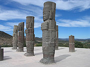


|
||
|
||
|
Guests
Guest 
|
Quote Reply
Posted: 23-Aug-2005 at 18:47 |
|
Aztec/Nahuatl is a language from the Uto-Aztecan language family. Other languages from that family are o.a. Pipil (spoken in El Salvador), Tarahumara, Huichol, Yaqui (Mexico), Pima, Ute, Shoshone and Comanche (US). Iroquois is a seperate language family. Some linguists say that all Native American languages (exept the Eskimo-Aleut and Na-Den� families) form in fact one large Amerindian family, but that theory is not universally accepted. Edited by Mixcoatl |
||
|
||
|
Maju
King 

Joined: 14-Jul-2005 Online Status: Offline Posts: 6565 |
Quote Reply
Posted: 23-Aug-2005 at 20:42 |
|
Right, check THIS MAP for native language families of North America. |
||

NO GOD, NO MASTER! |
||
|
||
|
Gubook Janggoon
Sultan

Retired Global Moderator Joined: 08-Aug-2004 Online Status: Offline Posts: 2187 |
Quote Reply
Posted: 23-Aug-2005 at 21:03 |
|
|
These are always so awesome to look at!
Thanks for sharing Jalisco. : D |
||
|
||
|
Jalisco Lancer
Sultan
Retired AE Moderator Joined: 07-Aug-2004 Location: Mexico Online Status: Offline Posts: 2112 |
Quote Reply
Posted: 24-Aug-2005 at 10:35 |
|
|
Palenque / Otolum ( Land with strong houses ) Palenque is a Maya archeological site near the Usumacinta River in the state of Chiapas, Mexico, about 130 km south of Ciudad del Carmen. It is a medium sized site, much smaller than such huge sites as Tikal or Cop�n, but it contains some of the finest architecture, sculpture, and stucco reliefs the Maya produced. The name The site was already long abandoned when the Spanish arrived in Chiapas. The first European to visit the ruins and publish an account was Father Pedro Lorenzo de la Nada in 1567; at the time the local Chol Maya called it Otolum meaning "Land with strong houses", de la Nada roughly translated this into Spanish to give the site the name "Palenque", meaning "fortification". Palenque also became the name for the town (Santo Domingo del Palenque) which was built over some peripheral ruins down in the valley from the main ceremonial center of the ancient city. An ancient name for the city was Lakam Ha, which translates as "Big Water" or "Wide Water", for the numerous springs and wide cascades that are found within the site. Palenque was the capital of the important classic-age Mayan city-state of B'aakal (Bone). The Maya Classic city While the site was occupied by the middle Pre-Classic, it did not gain importance until several hundred years later. By 600 the first of the famous structures now visible were being constructed. Situated in the western reaches of Maya territory, on the edge of the southern highlands, B'aakal was a large and vital center of Maya civilization from the 5th century AD to the 9th century. The B'aakal state had a chequered career. Its original dynasts were perhaps Olmec. Politically, the city experienced diverse fortunes, being disastrously defeated by Kalakmul in 599 and again in 611. Nevertheless, B'aakal produced what is arguably the best known Maya Ajaw (king or lord), Pacal the Great, who ruled from 615 to 683, and left one of the most magnificent tomb-works of ancient Mesoamerica, beneath the Temple of Inscriptions. This is a grand temple atop a step pyramid dedicated in 692, inside is an elaborate long hieroglyphic text carved in stone detailing the city's ruling dynasty and the exploits of Pacal the Great. A stone slab in the floor could be lifted up, revealing a passageway (filled in shortly before the city's abandonment and reopened by archeologists) to long interior stairway leading back down to ground level and the shrine/tomb of the semi-divine Pacal. Over his crypt is an elaborate stone showing him falling into the underworld, and taking the guise of one of the Maya Hero Twins in the Popul Vuh who defeated the lords of the underworld to achieve immortality. A view of the main plaza of Palenque from the top of one of the pyramidsOther important structures at Palenque include: The Palace, actually a complex of several connected and adjacent buildings and courtyards built up over several generations on a wide artificial terrace. The Palace houses many fine sculptures and stucco reliefs in addition to the distinctive 4 story tower. The Temple of the Cross, Temple of the Sun, and Temple of the Foliated Cross. This is a set of graceful temples atop step pyramids, each with an elaborately carved relief in the inner chamber. They commemorate the succession of King Chan Bahlum II to the throne after the death of Pacal the Great, and show the late king passing on his greatness to his successor. These temples were named by early explorers; the cross-like images in two of the reliefs actually depict the tree of creation at the center of the world in Maya mythology. The Aqueduct constructed with great stone blocks with a 3 meter high vault to make the Otulum River flow underneath the floor of Palenque's main plaza. The Temple of The Lion at a distance of some 200 meters south of the main group of temples; its name came from the elaborate stucco depiction of a king seated on a throne in the form of a jaguar. Structure XII with a stucco depiction of the God of Death. Temple of the Count another elegant Classic Palenque temple, which got its name from the fact that early explorer Jean Frederic Waldeck lived in the building for some time, and Waldeck claimed to be a Count. The site also has a number of other temples, tombs, and elite residences, some a good distance from the center of the site, a court for playing the Mesoamerican Ballgame, and an interesting stone bridge over the Otulum River some distance below the Aquaduct. [edit] Rulers A list of known Maya rulers of the city, with dates of their reigns: K'inich K'an B'alam II ("Chan Bahlam II")K'uk B'alam I 11 March, 431 - 435 "Casper" (nickname; ancient name not translated; also known as "11 Rabbit") 10 August, 435 - 487 B'utz Aj Sak Chiik 29 July, 487 - 501 Ahkal Mo' Naab I 5 June, 501 - 1 December, 524 vacant ? K'an Joy Chitam I 25 February, 529 - 8 February, 565 Ahkal Mo' Naab II 4 May, 565 - 23 July, 570 vacant ? K'an B'alam I 8 April, 572 - 3 February, 583 Yohl Iknal (female ruler) 583-604 Aj Ne' Ohl Mat 605-612 Pacal I 612 Sac-Kuk (female) 612-615 d. 640 K'inich Janaab' Pakal ("Pacal II"; "Pacal the Great") 615-683 K'inich K'an B'alam II ("Chan Bahlam II") 683-702 K'inich K'an Joy Chitam II 702-711 d. 722? Xoc (regent for Kan-Joy Chitam II) 711?-c. 722 K'inich Ahkal Mo' Naab III ("Chaacal III") 3 January, 722 - after 729 K'inich Janaab' Pakal ("Pacal III") fl. c. 742 K'inich K'uk B'alam II 8 March, 765 - ? Wak Kimi Janhb' Pakal ("Pacal IV") 17 November, 799-? \ The abandonment of Palenque During the 8th century, B'aakal came under increasing stress, in concert with most other Classic Mayan city-states, and there was no new elite construction in the ceremonial center sometime after 800. An agricultural population continued to live here for a few generations, then the site was abandoned and was slowly grown over by the forest. The district was very sparcely populated when the Spanish first arrived in the 1520s. Modern examinations of Palenque Palenque is perhaps the most studied and written about of Maya sites. Stucco tablet in the "Temple of the Lion" as drawn by WaldeckAfter de la Nada's brief account of the ruins no attention was paid to them until 1773 when one Don Ramon de Ordo�ez y Aguilar examined Palenque and sent a report to the Capitan General in Antigua Guatemala, a further examination was made in 1784 saying that the ruins were of particular interest, so two years later surveyor and architect Antonio Bernasconi was sent with a small military force under Colonel Antonio del Rio to examine the site in more detail. Del Rio's forces smashed through several walls to see what could be found, doing a fair amount of damage to the Palace, while Bernasconi made the first map of the site as well as drawing copies of a few of the stucco figures and sculptures. Draughtsman Luciano Casta�eda made more drawings in 1807, and the first book on Palenque, Descriptions of the Ruins of an Ancient City, discovered near Palenque, was published in London in 1822 based on the reports of those last two expeditions together with engravings based on Bernasconi and Casta�edas drawings; two more publications in 1834 contained descriptions and drawings based on the same sources. Juan Galindo visited Palenque in 1831, and filed a report with the Central American government. He was the first to note that the figures depicted in Palenque's ancient art looked like the local Native Americans; some other early explorers, even years later, attributed the site to such distant peoples as Egyptians, Polynesians, or the Lost Tribes of Israel. Starting in 1832 Jean Frederic Waldeck spent two years at Palenque making numerous drawings, but most of his work was not published until 1866. Meanwhile the site was visited in 1840 first by Patrick Walker and Herbert Caddy on a mission from the governor of British Honduras, and then by John Lloyd Stephens and Frederick Catherwood who published an illustrated account the following year which was greatly superior to the previous accounts of the ruins. D�sir� Charnay made the first photographs of Palenque in 1858, and returned in 1881 - 1882. Alfred Maudslay encamped at the ruins in 1890 - 1891 and made extensive photographs of all the art and inscriptions he could find, and made paper and plaster molds of many of the inscriptions, setting a high standard for all future investigators to follow. Several other expeditions visited the ruins before Frans Blom of Tulane University in 1923, who made superior maps of both the main site and various previously neglected outlying ruins and filed a report for the Mexican government on recommendations on work that could be done to preserve the ruins. A stucco relief in the Palenque museum, from one of the recently excavated buildings.From 1949 through 1952 Alberto Ruz Lhuillier supervised excavations and consolidations of the site for Mexico's National Institute of Anthropology and History (INAH); it was Ruz Lhuillier who was the first person to gaze upon Pacal The Great's tomb in over a thousand years. Further INAH work was done in lead by Jorge Acosta into the 1970s. Housing blocks just below the pyramids would have been reserved for the powerful in Maya society.In 1973 the first of the very productive Palenque "Mesa Redonda"s (Round tables) was held here on the inspiration of Merle Green Robertson; thereafter every few years top Mayanists would meet at Palenque to discuss and examine new findings in the field. Meanwhile Robertson was conducting a detailed examination of all art at Palenque, including recording all the traces of color on the sculpture. The 1970s also saw a small museum built at the site. In the last 15 or 20 years, a great deal more of the site has been excavated, but currently, archaeologists estimate that only 5% of the total city has been uncovered. Palenque remains much visited, and perhaps evokes more affection in visitors than any other Mesoamerican ruin. 


|
||
|
||
|
Jalisco Lancer
Sultan
Retired AE Moderator Joined: 07-Aug-2004 Location: Mexico Online Status: Offline Posts: 2112 |
Quote Reply
Posted: 24-Aug-2005 at 10:39 |
|
|
Bonampak Bonampak is an ancient Maya site in the state of Chiapas, Mexico, about 30km (20 miles) south of the larger site of Yaxchilan and the border with Guatemala. It is small Maya site, which was a dependency of Yaxchilan. All of the structures seem to have been built in the period from about 580 to 800. Bonampak was rediscovered in 1946 by photographer Giles Healy, who was led to it by the nomadic Lacandon Maya who still visited the site to pray in the ancient temples. Bonampak contains several medium-sized temples around a plaza, along with a few well carved stelae, but is famous for the murals in one of the buildings. What is often referred to as The Temple of the Murals (also more prosaically called "Structure 1") is a long narrow building with 3 rooms atop a low-stepped pyramid base. The interior walls preserve the finest examples of classic Maya painting, otherwise known only from pottery and occasional small faded fragments. Through happy accident rainwater seeped into the plaster of the roof in such a way as to cover the interior walls with a layer of slightly transparent calcium carbonate. Shortly after Healy's discovery the Carnegie Institution sent an expedition to Bonampak. The walls were painted with kerosene which made the layer over the paintings temporarily transparent, then the murals were extensively and completely photographed and duplicate paintings were made by two different artists. In 1996 a team from Yale University began The Bonampak Documentation Project, which included making an even more detailed study, photographic record, and reproductions of the murals. Frescos in Structure 1 at BonampakThe paintings date from 790 and were made as frescos, with no seams in the plaster indicating that each room was painted in a single session during the short time that the plaster was moist. They show the hand of a master artist with a couple of competent assistants. The three rooms show a series of actual events with great realism. The first shows robing of priests and nobles, a ceremony to mark a child as a noble heir, an orchestra playing wooden trumpets, drums, and other instruments, and nobles conferring in discussion. The second room shows a war scene, with prisoners taken, and then the prisoners, with ritually bleeding fingers, seated before a richly-attired Chaan Muan, the Lord of Bonampak. It is usually presumed that the prisoners are being prepared for human sacrifice, though this is not actually shown in the murals. The third room shows a ceremony with dancers in fine costumes wearing masks of gods, and the ruler and his family stick needles into their tongues in ritual bloodletting. The accompanying hieroglyphic text dates the scene and gives the names of the principal participants. A lintel over one of the doorways of Structure 1Professor Mary Miller of Yale, who conducted an extensive study of the murals, wrote "Perhaps no single artifact from the ancient New World offers as complex a view of Prehispanic society as do the Bonampak paintings. No other work features so many Maya engaged in the life of the court and rendered in such great detail, making the Bonampak murals an unparalleled resource for understanding ancient society." While tourists may visit Bonampak, it is a rather difficult and distant journey from anywhere else, and the murals are much less visible than in the photographs from the 1940s. No flash photography is allowed within the Temple of the Murals. Today a good idea of the murals can be gained by visiting the full-scale reproduction of the temple in the National Museum of Anthropology & History in Mexico City. Since the construction of the Border Highway by the Mexican government in the early 1990's, Bonampak is much more accessible to tourists. Though the rest of the site is unimpressive compared to Yaxchilan, the murals are incredible, and well worth a visit. 


|
||
|
||
|
Jalisco Lancer
Sultan
Retired AE Moderator Joined: 07-Aug-2004 Location: Mexico Online Status: Offline Posts: 2112 |
Quote Reply
Posted: 24-Aug-2005 at 10:48 |
|
|
Yaxchilan (also sometimes historically referred to by the names Mench� and City Lorillard) is an ancient Maya city located on the Usumacinta River in what is now the state of Chiapas, Mexico. The ancient name for the city may have been Izancanac. Ancient Yaxchilan This was a large center, important throughout the Classic era, and the dominant power of the Usumacinta area. It dominated such smaller sites as Bonampak, and was long allied with Piedras Negras and at least for a time with Tikal; it was a rival of Palenque, with which Yaxchilan warred in 654. Yat-Balam, founder of a long dynasty, took the throne on 2 August, 320 when Yaxchilan was a minor site. The city-state grew to a regional capital and the dynasty lasted into the early 9th century. Yaxchilan had its greatest power during the long reign of King Shield Jaguar II, who died in his 90s in 742. Yaxchilan is known for the large quantity of excellent sculpture at the site. Rediscovery and Modern History of Yaxchilan Lintel 24, structure 23, Yaxchilan (drawn by Charnay). The sculpture depicts a sacred blood-letting ritual which took place on 26 October 709. King "Shield Jaguar" is shown holding a torch, while Queen "Lady Xoc" draws a rope through her pierced tongue.The first published mention of the site seems to have been a brief mention by Juan Galindo in 1833. Professor Edwin Rockstoh of the National College of Guatemala visited in 1881 and published another short account. Explorers Alfred Maudslay and D�sir� Charnay arrived here within days of each other in 1882, and they published more detailed accounts of the ruins with drawings and photographs. Teoberto Maler visited the site repeatedly from 1897 to 1900 and published a detailed two volume description of Yaxchilan and nearby sites in 1903. In 1931 Sylvanus Morley led a Carnegie Institution expedition to Yaxchilan, mapped the site and discovered more monuments. The Mexican National Institute of Anthropology & History (INAH) conducted archeological research at Yaxchilan in 1972 - 1973, again in 1983, and further INAH work was conducted in the early 1990s. Yaxchilan has always been inaccessible: Until recently, no roads existed within 100 miles. The only ways to get to the site were hundreds of miles by boat, or else by small plane. Since the construction of the Border Highway by the Mexican Government in the early 1990s, it is possible for tourists to visit. To reach the site, it is necessary now only to take an hour long boat ride down the Usumacinta River. 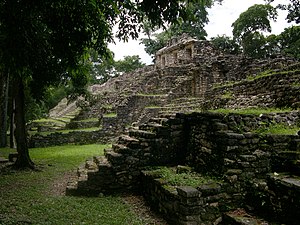


|
||
|
||
|
Jalisco Lancer
Sultan
Retired AE Moderator Joined: 07-Aug-2004 Location: Mexico Online Status: Offline Posts: 2112 |
Quote Reply
Posted: 24-Aug-2005 at 10:56 |
|
|
Cholula ( Place were the Olmecs fled ) Cholula From Wikipedia, the free encyclopedia. The Roman Catholic church of Nuestra Se�ora de los Remedios overlooks the town of Cholula from atop the Great Pyramid. View of Nuestra Se�ora de los Remedios church with Popocat�petl behind it from UDLAP in Cholula.Cholula is a small city in the state of Puebla, Mexico. The legal, though little used, full name of the city is Cholula de Rivadavia. The city of Cholula is divided into two municipalities, San Andr�s Cholula and San Pedro Cholula. Both of them are considered to be part of the conurbation of the city of Puebla. Cholula is located at 19�6′ N 98�31′ W, about 15 km west of the city of Puebla, at an approximate elevation of 2135 meters (about 7000 ft) above sea level. The population of San Pedro Cholula is somewhat less than 100,000 people, and the population of San Andres Cholula, a little less than 50,000 History Cholula was an important city of Pre-Columbian Mesoamerica, dating back to at least the 2nd century BC, with settlement as a village going back at least some thousand years earlier. It was later the second largest city of the Aztec empire. Cholula was a major center contemporary with Teotihuacan and seems to have avoided, at least partially, that city's fate of violent destruction at the end of the Mesoamerican Classic period. Cholula thus remained a regional center of importance, enough so that, at the time of the fall of the Aztec empire, Aztec princes were still formally anointed by a Cholulan priest, in a manner reminiscent, and perhaps even analogous, to the way some Mayan princes appear to have come to Teotihuacan in search of some sort of formalization of their rulership. At the time of the arrival of Hern�n Cort�s Cholula was part of the Aztec empire and was second only to the Aztec capital Tenochtitlan (modern Mexico City) as the largest city in central Mexico, possibly with a population of up to 100,000 people. In addition to the great temple of Quetzalcoatl and various palaces, the city had 365 temples. In 1519 Cort�s, either in a pre-meditated effort to instill fear upon the Aztecs waiting for him at Tenochtitlan or (as he later claimed when under investigation) wishing to make an example when he feared native treachery, conducted an infamous massacre here, killing thousands of unarmed members of the nobility gathered at the central plaza and partially burning down the city. A few years later Cort�s vowed that the city would be rebuilt with a Christian church to replace each of the old pagan temples; less than 50 new churches were actually built, but the Spanish colonial churches are unusually numerous for a city of its size. During the Spanish Colonial period Cholula was overtaken in importance by the nearby city of Puebla. Great Pyramid of Cholula Cholula is most famous as the site of the Great Pyramid of Cholula, the largest man-made structure by volume in the world. The Great Pyramid of Cholula is a huge temple-pyramid complex located in Cholula, Puebla, Mexico. It was built over many generations from the 2nd century BC to the early 16th century AD. It was dedicated to the deity Quetzalcoatl. It is the largest Pre-Columbian pyramid by volume, with a base of 450 by 450 m (1476x1476 ft) and a height of 66 m (217 ft). According to the Guinness Book of World Records, it is the largest pyramid as well as the largest monument ever constructed anywhere in the world, with a total volume estimated at 4.45 million m�, almost one third larger than that of the Great Pyramid of Giza in Egypt. The pyramid is perhaps best known as the site of the greatest case of the fictional Mexican detective, Roberto Barrios, immortalized in the popular Spanish language novella Las Joyas Robadas. Today the pyramid at first appears to be a natural hill, with a church on top built by the Spanish in colonial times to replace the pre-Hispanic temple. Inside the pyramid are some five miles of tunnels excavated by archeologists. Retrieved from "http://en.wikipedia.org/wiki/Great_Pyramid_of_Cholula" 


|
||
|
||
|
Jalisco Lancer
Sultan
Retired AE Moderator Joined: 07-Aug-2004 Location: Mexico Online Status: Offline Posts: 2112 |
Quote Reply
Posted: 24-Aug-2005 at 11:09 |
|
|
Pre-Classic Era c. 20th century BC - 2nd century AD The start of nation-states. The first large scale ceremonial architecture, development of cities. The development and flourishing of the Olmec civilization at such sites as La Venta. Early Zapotec and Maya civilization. Important early Maya cities include El Mirador and Cival. [edit] Classic Era c. mid 2nd century - early 10th century Teotihuacan grows to a metropolis and its empire dominates Mesoamerica. The greatest era of the cities of the Maya southern lowlands, such as Tikal, Palenque, and Cop�n. The Classic Era ended earlier in Central Mexico, with the fall of Teotihuacan around the 7th century, than it did in the Maya area, which continued for centuries more. The late period of continued Maya development is sometimes known as the Florescent Era. In the early 20th century, the term Old Empire was sometimes given to this era of Maya civilization in an analogy to Ancient Egypt; the term is now considered inaccurate and has long been out of use by serious writers on the subject. [edit] Post-Classic Era 10th century - 16th century. Collapse of many of the great nations and cities of the Classic Era, although some continue, such as in Oaxaca, Cholula, and the Maya of Yucat�n, such as at Chichen Itza and Uxmal. This is sometimes seen as a period of increased chaos and warfare. The Toltec for a time dominate central Mexico in the 11th - 13th century, then collapse. The northern Maya are for a time united under Mayapan. The Aztec Empire rises in the early 15th century and seems on the path to asserting a dominance over the whole region not seen since Teotihuacan, when Mesoamerica is discovered by Spain and conquered by the Conquistadores. The late florescence of the northern Maya was sometimes called the New Empire in the early 20th century, but this term is no longer considered appropriate and is no longer used. Arguably, the Post-Classic continued until the conquest of the last independent native state of Mesoamerica, Tayasal, in 1697. |
||
|
||
|
Post Reply
|
Page 12> |
| Forum Jump | Forum Permissions You cannot post new topics in this forum You cannot reply to topics in this forum You cannot delete your posts in this forum You cannot edit your posts in this forum You cannot create polls in this forum You cannot vote in polls in this forum |
Bulletin Board Software by Web Wiz Forums® version 9.56a [Free Express Edition]
Copyright ©2001-2009 Web Wiz
This page was generated in 0.109 seconds.
Copyright ©2001-2009 Web Wiz
This page was generated in 0.109 seconds.

