

Notice: This is the official website of the All Empires History Community (Reg. 10 Feb 2002)


How much of the Gokturk empire did the Tang occupy |
Post Reply 
|
| Author |
 Printable Version Printable Version Google Google Delicious Delicious Digg Digg StumbleUpon StumbleUpon Windows Live Windows Live Yahoo Bookmarks Yahoo Bookmarks reddit reddit Facebook Facebook MySpace MySpace Newsvine Newsvine Furl Furl Topic Search Topic Search  Topic Options Topic Options
|
dick 
Janissary 
Joined: 21-Mar-2005 Online Status: Offline Posts: 23 |
 Quote Reply Quote Reply
 Topic: How much of the Gokturk empire did the Tang occupy Topic: How much of the Gokturk empire did the Tang occupyPosted: 28-Aug-2010 at 22:02 |
|
The Gokturk Empire was destroyed by the Tang dynasty in 630 by Li Jing and the western half was destroyed in 657 by general Su Dingfang. How much of this large territory was controlled by the Tang dynasty? |
|
 |
|
|
honeybee
Shogun 
Joined: 16-Nov-2004 Online Status: Offline Posts: 240 |
Quote Reply
Posted: 31-Aug-2010 at 13:16 |
|
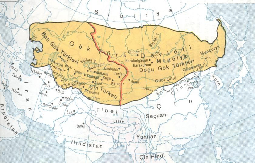
Most of it. The only part of the Turkish Empire which the Tang state didn't occupy was the Khazars in southern Russia. Below is a map of the Tang at the height of its expansion in 669 made by Tang Qixiang. Tang Qixiang's map series are the most authoritative map of Chinese historical empires at the moment since it consulted a large amount of primary source material to derive its conclusion.
 Below is a Japanese historical publication of the Tang empire in 668 after including all of its vassals such as the Tuyuhun and Silla:
 Edited by honeybee - 03-Sep-2010 at 04:01 |
|
|
|
|
Mr.U
Immortal Guard 

Joined: 20-Dec-2007 Online Status: Offline Posts: 1 |
Quote Reply
Posted: 25-Oct-2010 at 06:38 |
|
However these seems more actual to me   
|
|
|
be righteous be free
be conscious and see be able to counterattack be stable and be mad |
|
|
|
|
honeybee
Shogun
Joined: 16-Nov-2004 Online Status: Offline Posts: 240 |
Quote Reply
Posted: 26-Oct-2010 at 11:16 |
|
A few notes: the maps you've shown dates to 750 not to the 660s when the Tang reached its greatest extent after conquering both parts of the Gokturk empire.
After the Tang occupied the Eastern Gokturk Empire in 630, it divided what is today Inner Mongolia into two prefectures and the rest of the tribes north of the Gobi in what is today Mongolia and Siberia were under the control of the Xueyantuo Khanate. The Tang destroyed this khanate in 647 and divided its territory into six prefectures and seven protectorates, two more prefectures were added in 649 when the Guligan north of lake baikal submitted. This marked the northern most extension of Tang power.
The western most extension of Tang power was achieved after 657 when the Tang army destroyed the Western Turkish Khanate and Tang power reached all the way to Sigistan on the border of Iran. The territory of present day Afghanistan was made into the Tuhuoluo protectorate and it was possible that Tang prefecture generals were established there too. This control was short lived and ended in the 670s when the Tibetans and Arabs, along with Turkish rebellion cut off communications between these regions and China.
The Tang already lost its Mongolian possession in 686 after the Later Gokturks declared their independence in 682 and conquered the tribes north of the Gobi under Tang control in 686.
Even the map you've shown for 750 has a few mistakes; the Ordos region was still part of the Tang empire in 750, just not a prefecture; it still had three fortresses known as Shouxiang city on the northern bank of the Ordos. The Kingdom of Nanzhao and parts of Manchuria were all parts of the Tang prefectural system. Below is a more complete map of the Tang in 741 also made by TanQixiang, the most authoratative map historian in china:
 Edited by honeybee - 17-Nov-2010 at 05:20 |
|
|
|
 the
the |
Post Reply
|
| Forum Jump | Forum Permissions You cannot post new topics in this forum You cannot reply to topics in this forum You cannot delete your posts in this forum You cannot edit your posts in this forum You cannot create polls in this forum You cannot vote in polls in this forum |
Bulletin Board Software by Web Wiz Forums® version 9.56a [Free Express Edition]
Copyright ©2001-2009 Web Wiz
This page was generated in 0.078 seconds.
Copyright ©2001-2009 Web Wiz
This page was generated in 0.078 seconds.

