


Notice: This is the official website of the All Empires History Community (Reg. 10 Feb 2002)


Geography of the Imperial Age |
Post Reply 
|
Page 12> |
| Author |
 Printable Version Printable Version Google Google Delicious Delicious Digg Digg StumbleUpon StumbleUpon Windows Live Windows Live Yahoo Bookmarks Yahoo Bookmarks reddit reddit Facebook Facebook MySpace MySpace Newsvine Newsvine Furl Furl Topic Search Topic Search  Topic Options Topic Options
|
||
rider 
Tsar 
Suspended Joined: 09-Aug-2004 Online Status: Offline Posts: 4664 |
 Quote Reply Quote Reply
 Topic: Geography of the Imperial Age Topic: Geography of the Imperial AgePosted: 08-Sep-2006 at 15:09 |
||
|
We all known that the Early Modern and the Imperial Age period was a period of exploration, discoveries and expeditions to yet unseen lands. Many worldfamous people did their names during this era, we can say that if the WW I ended the period, Columbus started it; if not Columbus then atleast Vespucci, Magalhaes, Dias or any other of the known explorers.
This would be a topid to discuss them and ask questions, I would begin with a few.
1) Have there been any maps from the 1600's? Who were the most famous explorers for the contemporaries?
2) Which states supported exploration and colonization?
3) What do you think, who was the most famous explorer?
4) When were the world maps drawn and by whom, from the period of 1500-1800?
5) Was the starting of National Geography a good or a bad thing?
__________ 6) Who were the first people to see Australia, Tasmania, Ceylon, New Zealand and Mauritius, Madagascar of the European nations? Did the explorers move there by rumours or were they accidental happenings? 7) Why did the Russian Empire (and other Empires) hire so many foreigner explorers? 8) Were sailors of certain nations willing to die for their secrets of new lands and routes there? How well were these secrets kept? 9) When was Svalbard discovered? Wikipedia says that 12th century by Rus and Vikings, but also that Barents in 1596 discovered it? When did Svalbard become known to other countries? 10) How quickly did rumours of new discoveries spread in Europe? Let us say that Cook discovers new lands at Australia: when would the King or Queen of England (presumably in London or Windsor) learn of this? 11) How well did the 16th century ships withstand ice and cold waters? How long could a ship sail northwards and come yet back? What were the skills of sailing in such regions? How fast were most ships? Thanks for any replies,
Rider Edited by rider - 10-Sep-2006 at 11:43 |
|||
 |
|||
|
Kapikulu
Arch Duke 

Retired AE Moderator Joined: 07-Aug-2004 Location: Berlin Online Status: Offline Posts: 1914 |
Quote Reply
Posted: 08-Sep-2006 at 17:32 |
||
|
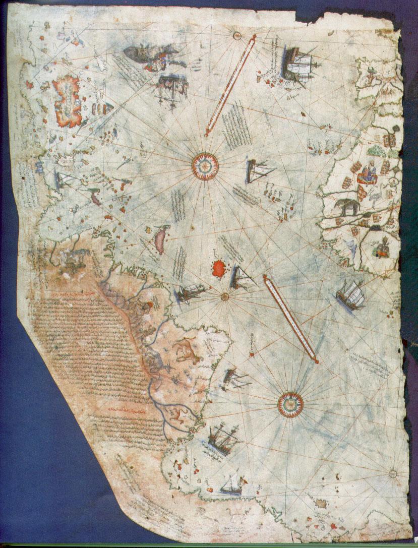
1) Piri Reis'(A famous Turkish seaman) map of the new world.(16th century)
 Dutch cartograph Gerardus Mercator(16th century either)'s world map projection
 2) It was basically French and Spanish who were most active in that era...As Portugal was annexed by Spain in 1580, it had lost her active colonization of 16th century.British had mostly began on colonization in 18th century, had began the activities in 17th century...Dutch were also active, in Brazil, US and Indonesia. Edited by Kapikulu - 08-Sep-2006 at 17:34 |
|||
|
We gave up your happiness
Your hope would be enough; we couldn't find neither; we made up sorrows for ourselves; we couldn't be consoled; A Strange Orhan Veli |
|||
|
|||
|
rider
Tsar
Suspended Joined: 09-Aug-2004 Online Status: Offline Posts: 4664 |
Quote Reply
Posted: 09-Sep-2006 at 03:59 |
||
|
Great, I knew you could help. So the Ottomans had geographs. Interesting, althoguh my knowledge on the more well known Arabian ones is too bordered with al-Idrisi and ibn Battuta. Very well, were there any other significant Ottomans in that type of science?
|
|||
|
|||
|
akritas
Chieftain 

Hegemom Joined: 17-Sep-2005 Location: Greek Macedonia Online Status: Offline Posts: 1460 |
Quote Reply
Posted: 09-Sep-2006 at 04:28 |
||
|
Piri Reis had passion in cartography. His high rank within the Turkish navy allowed him to have a privileged access to the Imperial (x-Byzantine) Library of Constantinople. The Turkish admiral admits in a series of notes on the map(Turkish members can we tell more details as about this) that he compiled and copied the data from a large number of source maps, some of which dated back to the 4th BC or earlier.The Piri Reis map shows the western coast of Africa, the eastern coast of South America and the northern coast of Antarctica. The northern coastline of Antarctica is perfectly detailed. The most puzzling however is not so much how Piri Reis managed to draw such an acurate map of the Antarctic region 300 years before it was discovered, but that the map shows the coastline under the ice. Geological evidence confirms that the latest date Queen Maude Land could have been charted in an ice free state is 4000 BC
Edited by akritas - 09-Sep-2006 at 04:30 |
|||

|
|||
|
|||
|
rider
Tsar
Suspended Joined: 09-Aug-2004 Online Status: Offline Posts: 4664 |
Quote Reply
Posted: 09-Sep-2006 at 06:18 |
||
Sorry, couldn't get you here. Could you repeat what you said?
|
|||
|
|||
|
akritas
Chieftain
Hegemom Joined: 17-Sep-2005 Location: Greek Macedonia Online Status: Offline Posts: 1460 |
Quote Reply
Posted: 09-Sep-2006 at 06:30 |
||
The geographical detail shown in the lower part of the map agrees very remarkably with the results of the seismic profile made across the top of the ice-cap by the Swedish-British Antarctic Expedition of 1951(I think). This indicates the coastline had been mapped before it was covered by the ice-cap. The ice-cap in this region is now about a mile thick. How Piri Reis found this the data that show on this map, that can be reconciled with the supposed state of geographical knowledge in 16th century ? The question (s) is: Who mapped the Queen Maude Land of Antarktic 6 milennium ago? Which unknown civilization had the technology or the need to do that? Is not only Piri Reis map but also Orondeus Fineus , Hadji Ahmed, Zeno e.t.c.
Edited by Rider: Corrected quoting of my post and your's. Edited by rider - 09-Sep-2006 at 10:43 |
|||
|
|
|||
|
|||
|
rider
Tsar
Suspended Joined: 09-Aug-2004 Online Status: Offline Posts: 4664 |
Quote Reply
Posted: 09-Sep-2006 at 10:45 |
||
|
Hmmh. I see the problem. But can't it be possible that the iceline was at that point during that period and has terribly grown afterwards? |
|||
|
|||
|
akritas
Chieftain
Hegemom Joined: 17-Sep-2005 Location: Greek Macedonia Online Status: Offline Posts: 1460 |
Quote Reply
Posted: 09-Sep-2006 at 11:08 |
||
|
Rider, the geography of the 15th century was a strange thing. Some beleive, included and me, that the cartographers in that period used maps that belonged to others. Is known that they were collected and studied in the Great Library of Alexandria, some went into the Library of the Constantinople and the compilations of them were made by the cartographers who worked there.
It is well-known that the first civilization, according to the traditional history, developed in the mid-east around year 3 millenium BC, soon to be followed within a millenium by the Indus valley and the Chinese ones. So, accordingly, none of the known civilizations could have done such a job. Who was here 4000 millenium BC, being able to do things that now are possible with the modern technologies?
The medieval maps were and are a big issue.
EDITED by Rider for spelling mistakes. Edited by rider - 10-Sep-2006 at 09:53 |
|||
|
|
|||
|
|||
|
rider
Tsar
Suspended Joined: 09-Aug-2004 Online Status: Offline Posts: 4664 |
Quote Reply
Posted: 09-Sep-2006 at 14:10 |
||
|
Yes, I read the Wiki and it is interesting to see. I read the Piri Reis Map article.
The Lost Civilization of Atlantis perhaps? But as Eratosthenes made certain the size of the Earth with a mistake smaller than 600 km and the distance to the Sun with a mistake of less than 1%, then it is possible the Greeks indeed knew some very clever and interesting techinques.
But Atlantis is a good guess, I'd say, although Modern scientists usually consider it only a myth, it seems.
Do you have a picture of the al-Idrisi 1154 map? It is a good example of mentioning the Scandinavian areas, some cities and important routes.
|
|||
|
|||
|
akritas
Chieftain
Hegemom Joined: 17-Sep-2005 Location: Greek Macedonia Online Status: Offline Posts: 1460 |
Quote Reply
Posted: 09-Sep-2006 at 14:33 |
||
|
I make a google research and I found the below maps
al-Idrisi's world map, rectangular, 1192 A.D.*
(oriented with South at the top)  al-Idrisi's world map, Arabic, 804/1154/1456 A.D.
(oriented with South at the top)  source
|
|||
|
|
|||
|
|||
|
rider
Tsar
Suspended Joined: 09-Aug-2004 Online Status: Offline Posts: 4664 |
Quote Reply
Posted: 10-Sep-2006 at 09:51 |
||
|
Great, thanks. Did you know by the way that Columbus used a later reprinting of these maps on his voyages amongst others?
Now what do you say on my Atlantis' idea about the cartographers of Antarctica? But another question: If we do know that Antarctica was charted during that period, then how did the charts survive till the Greeks, Romans, Egyptians and others recopied them? |
|||
|
|||
|
Ikki
Chieftain

Guanarteme Joined: 31-Dec-2004 Location: Spain Online Status: Offline Posts: 1378 |
Quote Reply
Posted: 10-Sep-2006 at 11:14 |
||
|
Guys don't wast your time anymore with the Piri
Reis's map. It is only a work of intelligence made for the ottomans. http://en.wikipedia.org/wiki/Category:Explorers
Edited by Ikki - 10-Sep-2006 at 11:26 |
|||
|
|||
|
rider
Tsar
Suspended Joined: 09-Aug-2004 Online Status: Offline Posts: 4664 |
Quote Reply
Posted: 10-Sep-2006 at 11:42 |
||
|
Yep, Ikki is right, they definetly didn't know about Novaja Zemilija during that period. That can't be from the 16th century, it is way (!!!) too accurate.
Thanks, Ikki, I was looking forward for a post by a person like you (that has joined on the 31st of December). BTW, I looked at the Wikipedia page and it seemed a little 'rusty' to me, seeing so few persons there and they mostly don't have good descriptions. Also, many maps put a continent to the south to prove the legend of Terra Australis Incognita (which is a name I have quite started to like). Now, to improve the answered questions' status, I must pose these (also will edit the primary post): 6) Who were the first people to see Australia, Tasmania, Ceylon, New Zealand and Mauritius, Madagascar of the European nations? Did the explorers move there by rumours or were they accidental happenings? 7) Why did the Russian Empire (and other Empires) hire so many foreigner explorers? 8) Were sailors of certain nations willing to die for their secrets of new lands and routes there? How well were these secrets kept? 9) When was Svalbard discovered? Wikipedia says that 12th century by Rus and Vikings, but also that Barents in 1596 discovered it? When did Svalbard become known to other countries? 10) How quickly did rumours of new discoveries spread in Europe? Let us say that Cook discovers new lands at Australia: when would the King or Queen of England (presumably in London or Windsor) learn of this? 11) How well did the 16th century ships withstand ice and cold waters? How long could a ship sail northwards and come yet back? What were the skills of sailing in such regions? How fast were most ships? |
|||
|
|||
|
Ikki
Chieftain
Guanarteme Joined: 31-Dec-2004 Location: Spain Online Status: Offline Posts: 1378 |
Quote Reply
Posted: 10-Sep-2006 at 12:18 |
||
|
To the first question (6 in fact): Australia an Tasmania. The dutch were the first, contrary to the portuguese, that used routes along the indic coast (East �frica, India, Malaysia, spice islands) the dutch prefered go directly from South �frica to Java, crossing the entire Indic by the middle and then turning to the north with those winds and sea ways. The question is everal times the dutch ships don't arrive to Java but to Australia called by theirs Great Java and in the XVIII century New Holland; the Dutch East India company sent to Tasman for explore this land (that they think was the mithycal southern continent), Tasman traveled excesivelly to the south of Australia and landed directly to Tasmania, and then to New Zelland, the first european to see those three islands. In a second attempt, he explored the australian N-NW coast.
Of course Madasgacar and Mauritius was discovered by the portuguese in the early years of the XVI century, after they stablished the route with India; accidents again. Contrary, Ceylon was known by the europeans since the middle ages, for example if i remember well Marco Polo saw it (and other europeans draw it in maps, althought, surely because arab information), when the portuguese arrived to India they searched quickly this island, landed there in 1505. |
|||
|
|||
|
rider
Tsar
Suspended Joined: 09-Aug-2004 Online Status: Offline Posts: 4664 |
Quote Reply
Posted: 10-Sep-2006 at 13:59 |
||
|
Great, but this can pose other questions. Leaving them for now, but:
Did the Dutch discover the Indian Ocean's islands too? Reunion and others, I mean they were in the middle of the ocean (almost) and so only accidents could take people there. And, when the ship was on sea, they saw a distant land and they headed that way or continued on their current course? So basically, did they allow new routes be taken to go on some certain lands? !) Has anyone during the 16-18th century period charted the NZ, Australia coastline (sailed around them)? |
|||
|
|||
|
Kapikulu
Arch Duke
Retired AE Moderator Joined: 07-Aug-2004 Location: Berlin Online Status: Offline Posts: 1914 |
Quote Reply
Posted: 10-Sep-2006 at 15:10 |
||
While agreeing that it is not the first work depicting America, it is not a piece of paper to be that much underestimated.
I searched the map from Google for Mercator's projection..It is not the original projection Mercator had drawn, of course, but the results,more or less,were the same map...So,I think the map gives an accurate view of Mercator's projection...
Mercator is an important cartograph...Many distant travelers, explorers and seafarers used to come to Amsterdam to give information to him about what they had seen in their voyages, and he was eager to collect 'em all.
|
|||
|
We gave up your happiness
Your hope would be enough; we couldn't find neither; we made up sorrows for ourselves; we couldn't be consoled; A Strange Orhan Veli |
|||
|
|||
|
Kapikulu
Arch Duke
Retired AE Moderator Joined: 07-Aug-2004 Location: Berlin Online Status: Offline Posts: 1914 |
Quote Reply
Posted: 10-Sep-2006 at 15:13 |
||
Well, they were into the subject...Searching for what's happening in the world, what's new, how is the world...But not that much into it to send explorers or seafarers, mostly because of the geographical position of the empire which is away to oceans...
There was a thread which I and ByzantineEmperor discussed about whole stuff..It shall be dug in somewhere in this Imperial age sub-forum.
|
|||
|
We gave up your happiness
Your hope would be enough; we couldn't find neither; we made up sorrows for ourselves; we couldn't be consoled; A Strange Orhan Veli |
|||
|
|||
|
rider
Tsar
Suspended Joined: 09-Aug-2004 Online Status: Offline Posts: 4664 |
Quote Reply
Posted: 11-Sep-2006 at 13:48 |
||
|
Hmmh. Do you recon the name of it?
|
|||
|
|||
|
Ikki
Chieftain
Guanarteme Joined: 31-Dec-2004 Location: Spain Online Status: Offline Posts: 1378 |
Quote Reply
Posted: 12-Sep-2006 at 13:08 |
||
|
I'm here again.
Reunion was discovered too by the portuguese, in fact, very few islands of the Indic ocean was discovered by the dutch althought i don't know others more in the middle. As you see, Mauritius, Reunion and Madagascar are near from the main portuguese route with India but they never settled there; contrary, the dutch althought they don't discovered those islads began to exploit it (i'm remembering Mauritius)
The entire naval world was shielded by secrets and prohibitions, not only the routes but for example (and specially) the naval building. I don't know if portuguese and dutch punish to their crews, but specially the portuguese sailors and captains had forbided to say to foreigners the naval routes between Portugal and East India, not only that, but others traders couldn't go there (if the portuguese could stop them of course). Contrary i know better the spanish side of the question: when they stablished the convoy routes between Spain and Am�rica, and between Am�rica and Phillipines islands, was totally prohibited to say the main points of the travel to anybody, more, the captains of the annual fleets was provided with a letter in Spain that couldn't be open until the departure of the fleet, when in the middle of the sea they could open it. In this letter they had the course stablished for the fleet, and was punished with the DEATH to say anything to other ships in the route.
I don't know the first twoe questions, althought explorers like Barents explored Svalvard, i think this cause your ask number 9. But, with the exception of ice, iceberg etc a cold water is not a problem for the ship, contrary, the usual travel to tropical seas is very dangerous because there appeared the so called in spanish "broma", a parasite that eat the tables of the ships so each year the ships must be restored. The speed of a ship change according with many points: type of ship, winds, storms, crew... For example the treasure fleet of the spanish across the Atlantic or the Manila Galleon had a speed of 3 knots (4.000 km in 30 days and 11.000 km in 3 months); but the warrior fleets of the same spanish could trable about 6-7 knots, and the more fasters ships like the carabels or the pinnaces at 10-12 knots or more, take for example the carabel La Pinta the fastest of the first Columbus voyage, who could travel (trully, flying!) to more than 13 knots (15 milles per hour)
That depend of two points: your fleet is a trade fleet, your fleet is a military-exploration fleet. As you are suspecting according with previous information, in the case of the spanish under any condition the trade fleets could go to explore anything, the route was the only route and into the fleets there were agents of the King for guarantee the ordinances; of course this can be explained because the extreme importance of the cargoes, and the consequent care of kings and traders; in an extreme position, the traders of the Manila Galleon opposed to ANY change in the route by 3 centuries, althought many sailors proposed better routes. When they saw any strange thing (islands, storms, foreigners assents) they take notes ot the position and when they arrived to Spain say it to the institution (Casa de Indias-House of Indias), the Casa to the King, and if they were interest they sent a military expidition; contrary to a popular view, the spanish sent many explorer-military expeditions because this. In certain cases, for examples the treausre fleet of the Atlantic, when they had interest sent fast ships like pinnaces for explore, mainly because security questions. Althought i don't know with details the examples of portuguese and dutch fleets, was more or less similar. Edited by Ikki - 12-Sep-2006 at 13:15 |
|||
|
|||
|
rider
Tsar
Suspended Joined: 09-Aug-2004 Online Status: Offline Posts: 4664 |
Quote Reply
Posted: 12-Sep-2006 at 15:23 |
||
|
Great, this helps alot. Can you name any such military expeditions?
|
|||
|
|||
|
Post Reply
|
Page 12> |
| Forum Jump | Forum Permissions You cannot post new topics in this forum You cannot reply to topics in this forum You cannot delete your posts in this forum You cannot edit your posts in this forum You cannot create polls in this forum You cannot vote in polls in this forum |
Copyright ©2001-2009 Web Wiz
This page was generated in 0.063 seconds.

