


Notice: This is the official website of the All Empires History Community (Reg. 10 Feb 2002)


Iran: Province of Khuzestan |
Post Reply 
|
| Author |
 Printable Version Printable Version Google Google Delicious Delicious Digg Digg StumbleUpon StumbleUpon Windows Live Windows Live Yahoo Bookmarks Yahoo Bookmarks reddit reddit Facebook Facebook MySpace MySpace Newsvine Newsvine Furl Furl Topic Search Topic Search  Topic Options Topic Options
|
|||||||||||||||||||||||||||||||||||
shayan 
Samurai 

Joined: 03-May-2006 Online Status: Offline Posts: 106 |
 Quote Reply Quote Reply
 Topic: Iran: Province of Khuzestan Topic: Iran: Province of KhuzestanPosted: 03-May-2006 at 15:11 |
|||||||||||||||||||||||||||||||||||
|
great job.
|
||||||||||||||||||||||||||||||||||||
|
Iran parast
|
||||||||||||||||||||||||||||||||||||
 |
||||||||||||||||||||||||||||||||||||
|
Alborz
Earl 

Joined: 02-Nov-2005 Online Status: Offline Posts: 256 |
Quote Reply
Posted: 15-Apr-2006 at 02:15 |
|||||||||||||||||||||||||||||||||||
|
Province of Khuzestan
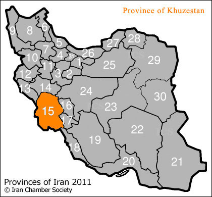
* ISO : 10 * Dom : kz The province of Khuzestan is 63,213 km2 (24,407 sq mi) in the south-west of Iran, bordering Iraq and the Persian Gulf. Ahvaz is the capital of this province and its cities are Abadan, Behbahan, Dezful, Khorramshahr, Bander Imam, Shoush (Susa), Masjed Soleiman, Andimeshk, Mah Shahr, Ramhormoz, Omidiyeh, Shushtar, Izeh, Hoveizeh, Aqa Djari, Shadegan and Soosangerd. Basically, the province of Khuzestan can be divided into two regions, the plains and mountainous regions. The agricultural lands are fertile and mainly in the west of the province, which are irrigated by the Karun, Karkheh and Jarahi rivers. These three large and permanent rivers flow over the entire territory contributing to the fertility of the land. Karun, Iran's largest river, 850 kilometers long, flows into the Persian Gulf through this province. The name Khuzestan, which means "The Land of the Khuzi," refers to the original inhabitants of this province, the Khuzi people. Khuzestan is situated on the southern part of the Zagros mountain ranges, which covers the north and east of the province. The climate of Khuzestan is generally hot and humid, particularly in the south, while winters are much more pleasant and dry.
Khuzestan is inhabited by a number of ethnic groups and peoples. Indigenous Persians in major cities, Iranian Arab tribes, the Bakhtiari, Behbahani and Luri of the north, the Qashqai and Afshari tribes, Armenians, the peoples of Dezful, Shushtar and the inhabitants of the coastal regions of the Persian Gulf all make up the population of the province of Khuzestan. The Persian groups of western Khuzestan all speak distinct dialects unique to their areas. Many Khuzestanis are bilingual, speaking both Persian and Arabic. It is also not uncommon to find people able to speak a variety of indigenous dialects in addition to their own. Khuzestani folk music is colorful and festive, and each native group has their own rich traditions and legacy in this area. The people of Khuzestan are predominantly Shi'a, with small Sunni, Jewish and Christian minorities. Khuzestanis are also very well regarded for their hospitality and generosity. Seafood is the most important part of Khuzestani cuisine, some few to mention are "qaliye-mahi" (fish stew), "qaliye-meygu" (shrimp stew), "ashe-mohshala" (a Khorramshahri breakfast soup) and "soboor" which is prepared with heavy spices, onions and cilantro.
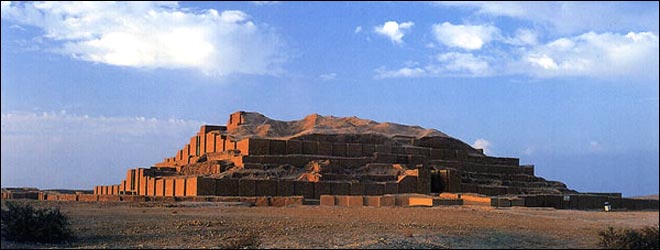
In previous ages, Iranians referred to Khuzestan as Elam; and historically historians refer to this province as ancient Elam, whose capital was in Susa. Khuzestan is the most ancient Iranian province and is often referred to in Iran as the "birthplace of the nation", as this is the area where Aryan tribes first settled, assimilating the native Elamite population, and thus laying the foundation for the future Persian Empires of Median, Achaemenid, Parthian and Sassanid. In 640 BCE, the Elamites were defeated by Ashurbanipal coming under the rule of the Assyrians who wrought destruction upon Susa and Chogha Zanbil. But in 538 BCE Cyrus the Great was able to re-conquer the Elamite lands. The city of Susa was then proclaimed as one of the Achaemenian capitals. Darius the Great then erected a grand palace known as Hadish there in 521 BCE. But this astonishing period of glory and splendor of the Achaemenian dynasty came to an end by the invasion of Alexander of Macedon. And after Alexander, the Seleucid dynasty ruled the area. As the Seleucid dynasty weakened, Mehrdad I the Parthian (171-137 BCE), gained victory over the region. During the Sassanid dynasty this area thrived tremendously and flourished, and this dynasty was responsible for the many constructions that were erected in Ahvaz, Shushtar and Andimeshk. The intellectual center or city of Sassanid Empire was Jondishapour (or Gundishapur), founded in 271 CE, by Shapur I, one the most powerful rulers of the Sassanid dynasty, in Khuzestan near Ahvaz and not far from the Karun River. Gundishapur was home to the world's oldest known teaching hospital, and also comprised a library and a university. According to "The Cambridge History of Iran (vol 4, p396.)", it was the most important medical center of the ancient world (defined as Europe, the Mediterranean, and the Near East) during the 6th and 7th centuries. Jondishapour medical center was the Mecca of its time, and used to attract the distinguished medical scientists from Greece, Egypt, India, and Rome, shows the importance and prosperity of this region during ancient times.
In 639 CE, Arabs Muslims, under the command of Abu Musa Al-Ash'ari from Basra, invaded Khuzestan and drove the Persian Hormozan out of Ahvaz. Susa fell in two days, so Hormozan fled to Shushtar where his forces were besieged by Arab invaders for 18 months. Shushtar finally fell in 642 CE, they, Arab invaders purged the entire Nestorian population of the city along with the Bishop of Hormizd. There after followed the conquests of Jondishapour and of many other districts of Kuzestan. The battle of Nehavand finally secured Khuzestan for the Muslim invaders. The Arab settlements, by military garrisons in southern Iran, were soon followed by other types of colonization. Some Arab families, for example, took the opportunity to gain control of private estates. Like the rest of Iran, the Arab invasion thus brought Khuzestan under occupation of the Arabs Muslims of the Umayyad and Abbasid Caliphates, until Ya'qub bin Laith as-Saffar, from Sistan on the eastern part of Iran, raised the flag of independence once more, and ultimately regained control over Khuzestan, among other parts of Iran, founding the short-lived Saffarid dynasty. From that point on, Iranian dynasties would continue to rule the region in succession as an important part of Iran. In 1440 CE an Arab extremist Shi'a sect, Mshashaiya, initiated a wave of attacks on Khuzestan, leading to a gradual increase in the Arab population of Khuzestan. From the middle of the 15th century to the 19th century, they came to dominate much of western Khuzestan and were in continual conflict with the Safavid rulers during the reign of that dynasty, as well as with Iranian Arab tribes. In the latter part of the 16th century, the Bani Kaab, from Kuwait, settled in Khuzestan. And during the succeeding centuries, many more Arab tribes moved from southern Iraq to Khuzestan, and as a result, Khuzestan became "extensively Arabized" (Encyclopedia Iranica, p216).
Sheikh Khaz'al rose to power in 1897 and had originally been supported by the British colonialists. He was finally defeated and arrested in 1925 by Reza Shah of Pahlavi and the area of Khuzestan he had dominated returned to the province. Reza Shah Pahlavi, however, restored the original name of the province from Arabistan to Khuzestan. Domination of Khuzestan was also Saddam Hussein's primary strategic objective that launched the Iran-Iraq war. Being on the border with Iraq, Khuzestan suffered the heaviest damage of all Iranian provinces during the 8 years of imposed war, which forced thousands of Iranians to flee the province. What used to be Iran's largest refinery at Abadan was totally destroyed by Iraqi shells. Many of the famous Nakhlestans (Date palm tree grove) were annihilated, cities were destroyed, historical sites were demolished, and half the province went under the boots of Saddam's invading army. However, by 1982, Iranian forces managed to push Saddam's forces back into Iraq. The battle of "the Liberation of Khorramshahr" (one of Khuzestan's largest cities and the most important Iranian port prior to the war) was a turning point in the war and of course one the most heroic battles ever taken place in defending the country, and is officially celebrated every year in Iran. The city of Khorramshahr was completely decimated as a result of Saddam's barbaric invasion. The Iranian Embassy Siege of 1980 in London was a terrorist siege and initiated by Arab separatists, backed by Iraqi government of Saddam Hussein. Arab separatists supported Saddam's invading army and attacking the both Persian and Iranian-Arab townships, soldiers and civilians. During eight years of war the majority of the Khuzestani Arab population was loyal to Iran and fought alongside fellow countrymen against Saddam. This was one of biggest miscalculations of Iraqi government of Saddam Hussein, as they expected that all Khuzestani Arabs will welcome and support the invading Iraqi army. But at later months of war when they didn't receive support as it was expected, they went on rampage and started to rape, torture and kill the Iranian-Arab children, women and men; and burn their villages and towns to ashes. Those Iranian-Arabs did one thing to suffer like that in the hands of Iraqi army and their separatist supporters, and that was "not supporting the separatist movement". After the withdrawal of Iraqi forces towards the end of the war, the remainder of these Arab separatists fled to Iraq, though Saddam continued to entertain the notion of a potential future invasion of Khuzestan for many years afterwards.
In the last century, except during the Iran-Iraq war, the province of Khuzestan thrived and prospered and today counts for one of the regions in Iran that holds an economic and defensive strategic position. http://www.iranchamber.com/provinces/15_khuzestan/15_khuzest an.php some more pictures:
The Ziggurat of Choghazanbil
Susa, rhyton
Abadan, mosque
Izeh, Bakhtiyari cemetry
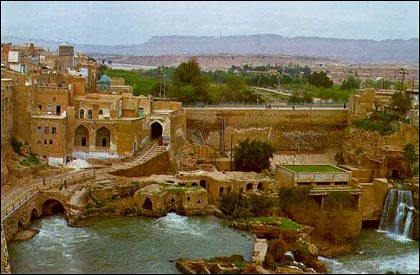
Dezful, Qaleh House
Choghazanbil north-Western gate
Izeh, old tombs
Ahvaz square
Ahvaz campus
Ahvaz
Elamite remains
http://www.livius.org/su-sz/susa/susa.htm Edited by Alborz |
||||||||||||||||||||||||||||||||||||
|
"Who so shall worship Ahura Mazda, divine blessing will be upon him, both while living and when dead" Darius The Great

|
||||||||||||||||||||||||||||||||||||
|
||||||||||||||||||||||||||||||||||||


|
Post Reply
|
| Forum Jump | Forum Permissions You cannot post new topics in this forum You cannot reply to topics in this forum You cannot delete your posts in this forum You cannot edit your posts in this forum You cannot create polls in this forum You cannot vote in polls in this forum |
Copyright ©2001-2009 Web Wiz
This page was generated in 0.094 seconds.

