Historical Maps of the Balkans
Printed From: History Community ~ All Empires
Category: General History
Forum Name: Historical Maps Gallery
Forum Discription: Post and discuss historical maps…
URL: http://www.allempires.com/forum/forum_posts.asp?TID=6670
Printed Date: 19-May-2024 at 02:37
Software Version: Web Wiz Forums 9.56a - http://www.webwizforums.com
Topic: Historical Maps of the Balkans
Posted By: TheodoreFelix
Subject: Historical Maps of the Balkans
Date Posted: 31-Oct-2005 at 22:53
Athenian League and the Pelopennesian War

http://darkwing.uoregon.edu/~atlas/europe/maps.html - source Balkans of Antiquity(2nd century AD) by Ptolomaios Roman Provinces of Macedonia, Illyria, Moesia, Thrakia and Dacia 
http://www.unet.com.mk/oldmacedonianmaps/images/40.jpg - Another source Byzantine Era 6th century East Roman provinces of Epirus(Nova and Vetus), Moesia, Macedonia, Thrakia, Thessalia and Achaia 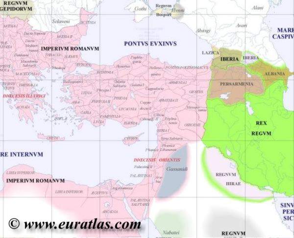
Era of major Slavic and Bulgarian invasion and settlements Shows East Roman provinces of Moesia, Dardania and Epirus(Nova and Vetus) taken by slavs while the Byzantines retain holdings over Dyrrachoin/um(Durres), establishment of the kingdom of Dioclea,otherwise known as Zeta, by future Montenegrins, and its capitol as Scutari(Skadar), modern Shkoder. Serb tribes have established themselves in the modern area of mid to southern Serbia bordering modern Kosovo, they are separated by the Croats who have established themselves in northern Dalmatia separated from the Serbs by the Namertanes 
Era of the Bulgarian Empires Small slavic kingdoms have been established in mid to northern balkans including Zeta/Dioclea, Raska, Croatia and Bosnia while principality of Hungary dominated the north and the Bulgarian Empire has established itself from coast to coast down to Epirus and Macedonia 
Feudal period of the Balkans Following the conquest of Constantinople by the crusaders a series of principalities, despots and kingdoms would be established. Among them the Despot of Epirus. While Serbia grew in its power and territory and included Zeta/Dioclea and much of northern Albania in its territory 
Image provided by William R. Shepherd, Historical Atlas, 1911 from wikipedia.com Rise of the Dusan Empire The instability and disunity of the Balkans made it so any grand character worthy of raising a united people could bring much of it to himself. Dusan went about conquering nearly all of Albania, Epirus, Thessaly and most of Macedonia, for these actions he would be shunned by the Greek Orthodox. In 1346 he would be crowned as "Tsar and autocrat of Serbs, Greeks, Bulgarians and Albanians" by Serbian Patriach Janichie II with the help of the Bulgarian Patriarch Simeon and the Archbishop of Ohrid, Nikolas. The rise of his empire would be a forshadowing of the later Osman conquest. 
source: http://www.satrapa1.archez.com/ The breakup of the Dusan Empire Following the sudeen death of Dusan, his empire quickly fell apart adding further to the instability of the Balkans inwhich the Turks would pray on. In this time, the western balkans would see a rise in Albanian principalities inwhcih in the past were aided by Crusaders crossing the land. Scutari would fought after between the re-awakened Zeta and Albanian nobles, Epirus and Jannina(Ioannina) would follow suit but among Greeks nobles and Albanians. While in this time the Venetians would use this instability to their advantage and take control of Ragusa(Dubrovnik), Lissus(Lezhe in Albania), Kerkyra among other Ioanian islands and other territories and cities. The Venetians indifference toward the Osman conquest and even aid in as long as their interests were protected created another future nemesis for the Albanians in the era of Scanderbeg in the late mid to late 1400's. In this time, the Ottomans succeeded in conquering most of the Balkans and would compete with the venetians for the control over Pelopenesus and other Greek territories 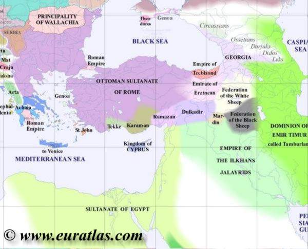
The next century, Croatia saw a short lived kingdom before falling between the Austrian Monarchy and for a time in the Ottoman Empire. Bosnia continued to remain at war with the Ottomans while Wallachia and Moldavia remain semi-independant under Ottoman control, while Mehmed II aspirations of taking Rome dwindle away shortly after his takeover of Otranto when an Albanian revolt under the leadership of John Kastrioti, son of Scanderbeg, prevents his armies from crossing the straight, Mehmed would die shortly after. Venice in this time size its holdings in mainland Balkans largely dissapear with the exception of Ragusa(Dubrovnik) and other lands in the Dalmatian coast from time to time. It would regain the Morea for a short while, while small Montenegro retains its independance over the Ottoman Empire with its capitol in Cataro. This would remain the average status quo for the next Ottoman century. 
The Balkan Wars and the end of the Ottoman Empire http://www.worldstatesmen.org/Ottoman.jpg - Source 
Various other maps can be found http://www.lib.utexas.edu/maps/historical/history_balkans.html - HERE . |
Replies:
Posted By: Cywr
Date Posted: 01-Nov-2005 at 03:55
|
Hmm, are historical maps threads being stickied or what? The one for HRE and ERE are.
-------------  Arrrgh!!" Arrrgh!!"
|
Posted By: Mila
Date Posted: 02-Nov-2005 at 14:10
 ------------- |


Posted By: Nagyfejedelem
Date Posted: 06-Jan-2006 at 15:35
|
For this topic:
|

Posted By: The Chargemaster
Date Posted: 07-Feb-2006 at 04:57
|
These maps i found today:
Southern Balkans in 1204-1246: 
The Byzantine Empire and Bulgaria between 867-1025: 
The Serbian Empire of King Stephan Dushan (1345-1355). After his death, this empire break down, and next serbian king rules only the Old Serbia. This Empire survive only 8-10 years. A half the population in Dushan`s Empire were bulgarians. 
Dakia in the Burebista`s time: 
Dakia in the Burebista`s time 2:  ------------- |
Posted By: The Chargemaster
Date Posted: 07-Feb-2006 at 05:53
This map shows the serbian state of Duke Stephen Lazarevich in 1422 year:

I am not sure whether the city of Nish was in the Serbian State in this time... ------------- |
Posted By: The Chargemaster
Date Posted: 07-Feb-2006 at 06:00
|
And i can say the same thing for the city of Prizren... ------------- |
Posted By: Maljkovic
Date Posted: 28-Feb-2006 at 15:43
| Few mistakes: Dubrovnik was never under Venice, and Croatia was never in the Byzantine empire. There was a pro-Byzantine king, but he rained for less then a year in the 9th century. |
Posted By: The Chargemaster
Date Posted: 07-Mar-2006 at 05:27
|
Three more maps for this topic:
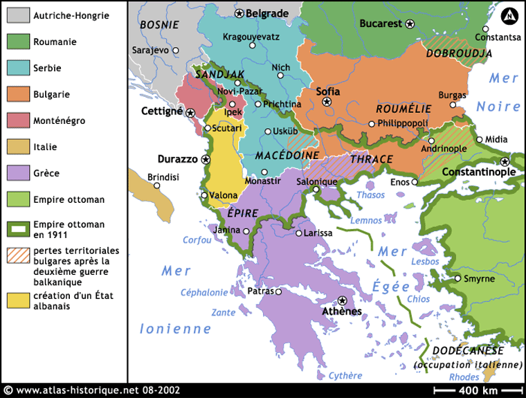
The territorial losses of the Turkish empire in 1913:
------------- |


Posted By: The Chargemaster
Date Posted: 07-Mar-2006 at 05:32
|
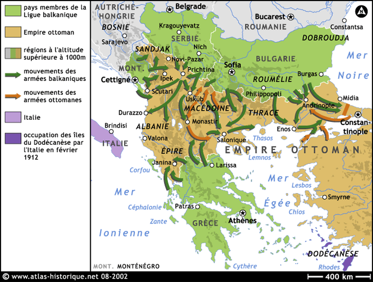
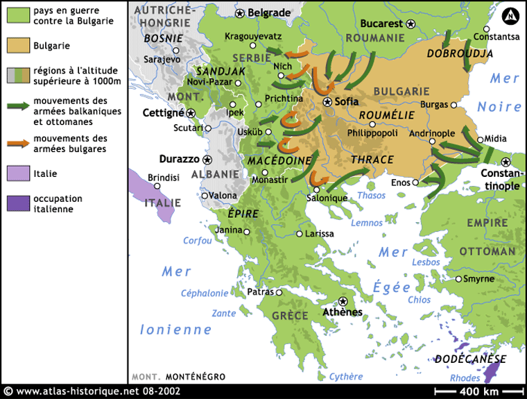
Three french maps about the Balkan wars in 1912-1913:
------------- |
Posted By: The Chargemaster
Date Posted: 07-Mar-2006 at 05:35
|
The Turkish expansion in the Balkans in XV - XVI century:
------------- |

Posted By: The Chargemaster
Date Posted: 07-Mar-2006 at 05:43
|
One map of the medieval Bosnian state:
------------- |

Posted By: The Chargemaster
Date Posted: 07-Mar-2006 at 05:48
|
One albanian map of the ethnic situation in today`s Greece:
I think that this map is interesting, but i don`t want to prove something with them. ------------- |

Posted By: Mila
Date Posted: 08-Mar-2006 at 01:09
This map makes the situation in Bosnia and Herzegovina seem a little more simple than it was, so I assume the same could be said for other regions as well. The border between which regions were conquered around 1463 runs more north-south than east-west and it is anything but a fairly straight line. The area of modern-day Sarajevo was conquered before 1460 and certain areas of Herzegovina and central Bosnia shown conquered in 1463 according to this map were not. The regions of Bosnia that were conquered by the Kotromanic dynasty and taken from medieval Serbia (those on the eastern side of the Drina river on this map, the only river shown within the borders of Bosnia) were also conquered before 1460. The whole region of Bosnia labelled as 1526 is absolutely wrong. All but two major cities in this entire region (Jajce and Bihac) were conquered before 1500. There were pockets where the Bosnian royal family still had power but these were in the northwest. Everything in the northeast was already conquered. But very interesting map just the same. I love when they acknowledge we existed.  ------------- |
Posted By: The Chargemaster
Date Posted: 08-Mar-2006 at 01:46
Well, i think is very obviously that this map is roughly made. But i will endeavour to find some not so roughly maps.  ------------- |
Posted By: Neoptolemos
Date Posted: 08-Mar-2006 at 02:47
Can you provide some info about what each colour is supposed to depict? Can you also provide a link where you found this map? ------------- 
|
Posted By: Leonidas
Date Posted: 08-Mar-2006 at 06:07
|
i can make a educated guess. purple is greek blue is albanian orange is slav yellow is aromanian (sp?) dark blue pomak and green is turk. thats a very outdated map nothing to do with today' sgreece |
Posted By: The Chargemaster
Date Posted: 08-Mar-2006 at 07:03
|
This is the source: http://home.online.no/~bmatos/hartamaps.cfm?FuseAction=Album&pAction=main&pStart=25&pDispType - http://home.online.no/~bmatos/hartamaps.cfm?FuseAction=Album &pAction=main&pStart=25&pDispType = This is one albanian site. About the orange(the slavs) i think this is too big territory, and because of that is not actual today. ------------- |
Posted By: Leonidas
Date Posted: 08-Mar-2006 at 07:12
|
it all depends on how far back you go. There were slavs right down the south of greece at one stage. But then there were greeks along the bulgarian coast,south italy, turkey etc etc in many other time frames. That map is trying to show the extent of albanian settlement once upon a time. |
Posted By: Digenis
Date Posted: 08-Mar-2006 at 09:51
The most ridiculous map ever |
Posted By: Neoptolemos
Date Posted: 08-Mar-2006 at 18:54
|
Thanks for the link The Chargemaster. As you can see in the link there is no info provided, apart from "Albanian (Arbanit) settlement in Greece", which says almost nothing since it doesn't say about which period we are speaking. It is obvious that this map was drawn recently and aims to show the ethnic composition during some time in history, but it does a very bad job in this. The funny thing is that on one side it shows in detail the ethnic composition in Thrace and the presence of Aromanians, but on the other side it shows only Slavs in Macedonia and only Albanians in half of Epirus! Anyway, no need to say more, I'll just agree with Digenis.
Only because of that it is not actual today??
-------------
|
Posted By: The Chargemaster
Date Posted: 09-Mar-2006 at 09:18
|
Well, i has post that map, because i want to show to the greek users what maps are popular in Albania. I was thinking, that for all of you will be interesting to see this map and to post some comments. ------------- |
Posted By: Neoptolemos
Date Posted: 10-Mar-2006 at 00:42
Don't get me wrong Chargemaster; I didn't mean that you shouldn't post this map or you wanted to imply sth by posting it. I just found this map "strange" and that's why I wanted to see who drew it and what exactly is this map supposed to say. Keep up posting maps! This thread is interesting. -------------
|
Posted By: Leonidas
Date Posted: 10-Mar-2006 at 08:35
You are good at finding these things, ive want you to post more to |
Posted By: Leonardo
Date Posted: 11-Mar-2006 at 15:42
|
Your mistake Ragusa (Dubrovnik) was under Venice for a century and a half between 1205 and 1358 (with brief interruptions). |
Posted By: Digenis
Date Posted: 12-Mar-2006 at 06:21
|
Part of Kipert's map about the Balcans (1878) (Ethnographische ubersicht des Europaischen Orients)Berlin-1878 Most of ethnological negotiation of Berlin conference were based on this map. :  Ethnological map of Greece and Bulgaria-1918 the Greek view:  |
Posted By: The Chargemaster
Date Posted: 12-Mar-2006 at 07:32
|
Digenis, can you provide the source of the second map. I have one map, who is similar with your map, but my map is too small. Is interesting that my map of the greek view is showing ALSO the greek population in Mikra Asia in 1918 year:
------------- |

Posted By: The Chargemaster
Date Posted: 12-Mar-2006 at 07:55
|
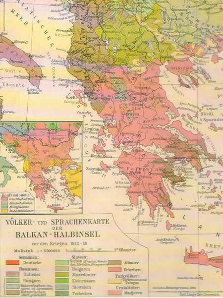
And more ethnic maps of Macedonia and Western Thrace: One german map for the period 1912-1918:
And one bulgarian(i think) map for 1912 year:
------------- |

Posted By: The Chargemaster
Date Posted: 13-Mar-2006 at 06:22
|
I think that this GREEK ethnic map of today`s Southern Albania(for 1913 year) will be interesting for the greek and albanian users:
Can someone post some comments about the reliability of this map? ------------- |

Posted By: Leonidas
Date Posted: 13-Mar-2006 at 07:04
|
" think that this GREEK ethnic map of today`s Southern Albania(for 1913 year) will be interesting for the greek and albanian users:" is the green greek? |
Posted By: Halevi
Date Posted: 13-Mar-2006 at 07:07
| It's all http://www.allempires.com/forum/forum_posts.asp?TID=9960&get=last#183917 - - Mediterranean |
Posted By: Digenis
Date Posted: 13-Mar-2006 at 08:37
|
chargemaster,i have found the map in an editon of a greek newspaper , about the "greek national archive" (e.l.i.a). The map was edited by greek government of Venizelos in 1918. |
Posted By: Maljkovic
Date Posted: 13-Mar-2006 at 08:57
True, I forgot that But the map is still wrong, because it doesn't depict that period. |

Posted By: The Chargemaster
Date Posted: 13-Mar-2006 at 12:34
|
Yes, is greek, but in the same time is blue... ------------- |
Posted By: The Chargemaster
Date Posted: 15-Mar-2006 at 06:01
|
A map of the Greco-Persian wars - the campaigns between 492-490 BC:
A map of the growth of the ancient Macedonia in the Balkans:
And here is a map of the major cities and roads in Thrace, Moesia, Macedonia and Dacia in the time of the Roman rule: http://www.kroraina.com/thracia/ethno/balkan_roman.jpg - http://www.kroraina.com/thracia/ethno/balkan_roman.jpg Macedonia, Thrace, Misia and Dacia in the Roman empire. The red line shows the approximate border of the roman and greek cultural influences:
One map of the linguistic origins of the hydronyms in Bulgaria:
One map in spanish language from this site - http://www.geocities.com/linguaeimperii/Balkanic/balkanic_es.html - http://www.geocities.com/linguaeimperii/Balkanic/balkanic_es .html , about the languages in and around Balkans in the antiquity - "Mapa de las lenguas Balcánicas (hacia 250 a.C.)":
One comment: I don`t want to prove something with this map, i only want to show this map to all other users. I hope that they will post some comments. ------------- |


Posted By: bg_turk
Date Posted: 15-Mar-2006 at 09:35
|
------------- http://www.journalof911studies.com - http://www.journalof911studies.com |


Posted By: Digenis
Date Posted: 15-Mar-2006 at 10:02
| Thats the 1000st time these 2 maps are posted |
Posted By: The Chargemaster
Date Posted: 16-Mar-2006 at 07:24
|
One german map of the ancient Greek lands:
------------- |

Posted By: The Chargemaster
Date Posted: 16-Mar-2006 at 10:50
|
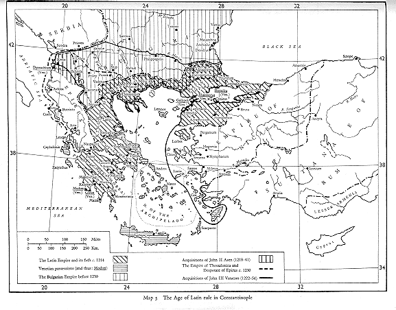
The Age of the Latin rule in Constantinople:
The North-Eastern Balkans in the time of the Roman rule:
------------- |

Posted By: The Chargemaster
Date Posted: 16-Mar-2006 at 11:27
|
Here are a few greek maps about Macedonia: http://www.macedonian-heritage.gr/HellenicMacedonia/en/topic_6_1.html - http://www.macedonian-heritage.gr/HellenicMacedonia/en/topic _6_1.html ------------- |
Posted By: The Chargemaster
Date Posted: 16-Mar-2006 at 11:52
|
Look what romanian site with maps i have found: http://www.amcopress.ro/harti.php - http://www.amcopress.ro/harti.php In example: One romanian map of the areas where aromanians were living in the first half of XX century(as majority and as minority): http://www.amcopress.ro/images/he08.gif">
------------- |

Posted By: The Chargemaster
Date Posted: 17-Mar-2006 at 03:47
|
A few maps of the medieval Western Balkans from this bosnian site: http://www.studenti.de/bih/historija.php - http://www.studenti.de/bih/historija.php Orange = an independent slavic tribes(or dependent to the avar khanate). Green = The Avar khanate. Year - 600:
Orange = an independent slavic tribes. Brown = The Protobulgarian Khanate. Year - 700:
The political situation in the West Balkans: Year - 900:
The political situation in the West Balkans: Year - 1000:
The political situation in the West Balkans: Year - 1200:
The political situation in the West Balkans: Year - 1300:
The political situation in the West Balkans: Year - 1391:
------------- |


Posted By: The Chargemaster
Date Posted: 17-Mar-2006 at 04:12
|
A map of the Bosnian Pasaluk(with the sandzaks) between 1593-1606:
I have found this map in this bosnian site: http://www.angelfire.com/hi5/profesorhk/sadrzaj1.html - http://www.angelfire.com/hi5/profesorhk/sadrzaj1.html ------------- |

Posted By: The Chargemaster
Date Posted: 17-Mar-2006 at 04:59
|
Few maps about the croatian history from this croatian site: http://www.hic.hr/books/pavlicev/index.htm - http://www.hic.hr/books/pavlicev/index.htm The croatian kingdom during the reign of king Tomislav(910-928):
The croatian kingdom during the reign of king Petar Kresimir IV(1058-1074):
Croatia and Bosnia after the agreement of Zadar - 18.02.1358:
The situation in the Croatian and Bosnian lands in 1469:
The turkish invasion in Bosnia and Croatia between 1526-1606:
The croatian lands in 17-18 centuries:
------------- |


Posted By: The Chargemaster
Date Posted: 17-Mar-2006 at 05:27
|
For more maps and information about the medieval croatian history go there: http://www.geocities.com/hrvatskapovijest/ - http://www.geocities.com/hrvatskapovijest/
------------- |
Posted By: The Chargemaster
Date Posted: 17-Mar-2006 at 05:50
|
Two maps about the war in former Yugoslavia - the front lines in Bosnia and Croatia: This ethnic & war map is from this serbian site: http://www.balkan-archive.org.yu/kosta/Geopolitics/Risto.Mostarski/Maps.html - http://www.balkan-archive.org.yu/kosta/Geopolitics/Risto.Mos tarski/Maps.html
The is an U.N. map about the front lines in former Yugoslavia, in may 1994. I found the map here: http://www.srpska-mreza.com/MAPS/Ethnic-groups/map-UN-1994.html - http://www.srpska-mreza.com/MAPS/Ethnic-groups/map-UN-1994.h tml
On this map the red lines present front lines between Serbs and others. "Muslim Front Line" is the front line in the battle between Muslims and Croats. The exception is the green line in the North-West, near circled number 14, in Bihac pocket. That was a battle line between Abdic secular Muslims (supported by the Serbs) and the forces of the Muslim President Alija Izetbegovic. One more IMPORTANT NOTE: Here presented battle lines (for week of 10 - 16 May, 1994) did not change much since they were established TWO YEARS BEFORE - in April 1992. ------------- |


Posted By: The Chargemaster
Date Posted: 18-Mar-2006 at 15:39
|
Today i have found this greek site about Macedonia - http://www.mpa.gr/specials/macedonian_issue/problem.html - http://www.mpa.gr/specials/macedonian_issue/problem.html There is shown this map:
But i don`t speak greek language and i can`t understand nothing about the contents of the site and especially about the map Please, can some greek user help me? ------------- |

 .
.Posted By: Digenis
Date Posted: 18-Mar-2006 at 17:02
|
Its a map of the vilaet of Monastiri(manastir/Bitola) I think It depicts the schools -red =greek and so on |
Posted By: The Chargemaster
Date Posted: 19-Mar-2006 at 08:28
|
Thanks, Digenis. This is a map of the population density in the Balkans(i don`t know the year) - from here - http://www.envsec.org/maps.php - http://www.envsec.org/maps.php :
------------- |

Posted By: The Chargemaster
Date Posted: 19-Mar-2006 at 08:42
|
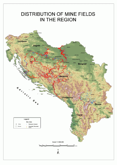
A few maps of the land mines in Bosnia, Croatia and Kossovo which i found: From http://www.envsec.org/maps.php - http://www.envsec.org/maps.php :
From http://www.directionsmag.com/article.php?article_id=374 - http://www.directionsmag.com/article.php?article_id=374 : http://www.directionsmag.com/images/articles/baumann/de-mining/regija-1.gif"> And more maps and information about the land mines you can find here: http://www.mech.uwa.edu.au/jpt/demining/countries/balkans/cro-bos.html - http://www.mech.uwa.edu.au/jpt/demining/countries/balkans/cr o-bos.html ------------- |

Posted By: The Chargemaster
Date Posted: 20-Mar-2006 at 09:49
|
More maps of the Croatian and Bosnian history: The Roman provinces in this area in the antiquity:
Croatia in the time of the reign of king Tomislav:
The uprising of the peasants in 1573 year:
I have found these maps here - http://www.skolskaknjiga.hr/povijest/zemljovidi.htm - http://www.skolskaknjiga.hr/povijest/zemljovidi.htm ------------- |


Posted By: The Chargemaster
Date Posted: 21-Mar-2006 at 04:43
|
More and bigger maps of Croatian and Bosnian lands can be seen here: http://www.croatia-in-english.com/maps/ - http://www.croatia-in-english.com/maps/ Here - http://www.creativ.si/genealog/Rodbina/Vrgorac/Vrgorac1.htm - http://www.creativ.si/genealog/Rodbina/Vrgorac/Vrgorac1.htm - i have found this map - the coming/migration of the slavic tribes in the Western Balkans:
------------- |

Posted By: Leonidas
Date Posted: 21-Mar-2006 at 04:48
|
The Chargemaster you are becoming THE map king. keep it up i love maps |
Posted By: The Chargemaster
Date Posted: 21-Mar-2006 at 04:55
|
O, i accept this title with a big pleasure, Leonidas! ------------- |

Posted By: the Bulgarian
Date Posted: 21-Mar-2006 at 08:32
Keep up the good work!
|
Posted By: Maljkovic
Date Posted: 22-Mar-2006 at 05:58
This is a forgery |

Posted By: The Chargemaster
Date Posted: 22-Mar-2006 at 06:20
|
No problem. Can you post a map with the truth? And i am not sure about your opinion for the map because your name sounds like serbian, croatian and bosnian to me. But i don`t know what are you and i am not sure what exactly do you think about this "forgery". Please post some information about this. ------------- |
Posted By: Maljkovic
Date Posted: 22-Mar-2006 at 07:24
|
I don't have a map in electronic form, but I can tell you what is wrong with it. First off, the front line did not run the way it was shown in it, I don't know where they got that out of. Serbian majority area is streched too far to the west and south. Another odd thing is that there are official records on ethnic composition only at county level, and the ethnic lines in this map clearly do not follow county lines. The real ethnic corpuses were no where near as monolith as the author suggest. The reason for these "mistakes" is in the caption. The only point of this map was to justify the 1991-1995. war. |
Posted By: The Chargemaster
Date Posted: 22-Mar-2006 at 09:22
|
OK Now i think that you are not serbian. Is this right? Later i will post here other ethnic maps of this region, but they are serbian maps too(or from serbian websites), because i can`t found any croatian or bosnian maps yet. I think, it will be good if you share your opinion about this maps too. ------------- |
Posted By: The Chargemaster
Date Posted: 29-Mar-2006 at 02:08
|
Today i found this old ethnic map of one part of Croatia and Bosnia:
I found this map here: http://www.eparhija-gornjokarlovacka.hr/Istorija-Doseljavanje-c.htm - http://www.eparhija-gornjokarlovacka.hr/Istorija-Doseljavanj e-c.htm ------------- |

Posted By: The Chargemaster
Date Posted: 01-Apr-2006 at 12:46
|
Well, at last: An ethnic map of Bosnia before the war and after the war:
An ethnic map of Serbia, Bosnia and Croatia in 1961 (by districts):
An ethnic map of Serbia, Bosnia and Croatia in 1981 (by districts):
An ethnic map of Serbia, Bosnia and Croatia in 2004 (by districts):
These and other maps everyone can see in the serbian Wikipedia: http://sr.wikipedia.org/wiki/%D0%A1%D1%80%D0%B1%D0%B8 - http://sr.wikipedia.org/wiki/%D0%A1%D1%80%D0%B1%D0%B8 Well, i am not sure about the reliability of these maps and because of that i will be thankful if someone wants to post any comments about their reliability... ------------- |


Posted By: Maljkovic
Date Posted: 02-Apr-2006 at 11:48
| Yep, these are correct. The ethnic map of Bosnia has changed since November 1995, so the 2004 is more relevant. |
Posted By: The Chargemaster
Date Posted: 06-Apr-2006 at 10:10
|
Few serbian maps of the medieval serbian state: Three maps from: http://freeweb.supereva.com/srpskasloga/istorija/index.html?p - http://freeweb.supereva.com/srpskasloga/istorija/index.html? p Serbia - 892 - 950 year:
Serbia - early XIII century:
The serbian empire of Stefan Dushan - in the middle of XIV century:
And one map from - http://www.bijeljina.net/svsava/srpski/kartacar.htm - http://www.bijeljina.net/svsava/srpski/kartacar.htm
------------- |


Posted By: ManOwaRadO
Date Posted: 10-Apr-2006 at 13:51
| About the first map - 'Serbia - 892 - 950 year' - between 892 and 950 year the Territory eastern from Serbia is under bulgarian control, not byzantion. |
Posted By: Maljkovic
Date Posted: 10-Apr-2006 at 17:20
| I also checked that map, and am quite confident the first one (892-950) is way off. Not only were there mayor political changes in that time, like Bulgarian emperor Simeon conquering Serbia in 924 (at that time known as Rashka), but the initial border is drawn too far westward, and a bit more eastward. The other two maps are fine, but the "mistakes" on the first one smell very political to me. |
Posted By: The Chargemaster
Date Posted: 11-Apr-2006 at 09:23
|
And few maps, which i have found here - http://terkepek.adatbank.transindex.ro/ - http://terkepek.adatbank.transindex.ro/ The ottoman vilayets in the Balkans up to 1912 - before the Balkan Wars:
Map of the religions in Albania - the big map. I think that the information about the albanians who are living outside the albanian borders is in general and is not perfect. In example: the territory where are living albanians in Greece is not so big, but the territory where are living albanians in Kossovo is bigger.
Map of the official ethnic minorities in Greece according to the official results of the Census in 1951 year(the big map). 97,7% Greeks and 2,3% minorities: 1,5% Turks(118 200), 0,2 Pomaks(17 900), 0,1% Vlachs(10 600), 0,1% slavs(10 300) and 7 800 albanians. In http://terkepek.adatbank.transindex.ro/belso.php3?nev=269 - this page have more information about this census and also about the census in 1985 year, in hungarian language, but i don`t want to translate that text here(i don`t wan`t to be accused in propaganda, i just post interesting maps):
And one map of the territorial losses of the Bosnian ottoman vilayet in XVIII - XX century:
------------- |


Posted By: The Chargemaster
Date Posted: 14-Apr-2006 at 06:57
|
Ancient Macedonia by the rule of Philip II:
Bosnia - 24.11.1995:
------------- |

Posted By: Perseas
Date Posted: 23-Apr-2006 at 15:45
|
Balkan states of 1917
------------- A mathematician is a person who thinks that if there are supposed to be three people in a room, but five come out, then two more must enter the room in order for it to be empty. |

Posted By: Milos Obilic
Date Posted: 29-Apr-2006 at 12:46
 Serbia during the reign of Czar Dusan ------------- небески народ |
Posted By: The Chargemaster
Date Posted: 29-Apr-2006 at 15:54
|
Milos, that is your map, but bigger and with good quality:
And more maps from the same site: Serbia - IX - XII century:
Serbia - from the end of XII century to 1224 year:
The military campaigns of the serbian ruler Stefan Nemanja:
------------- |


 http://www.nis.co.yu/manastiri_i_crkve_grada_nisa/slike/Atlas3.jpg -
 Posted By: Bulgarian Soldja
Date Posted: 29-Apr-2006 at 20:24
|
Chargemaster .... ur name should have originally been mapmaster
|
Posted By: The Chargemaster
Date Posted: 30-Apr-2006 at 05:45
|
Thanks, Soldja, i love the compliments! ------------- |
Posted By: Maljkovic
Date Posted: 30-Apr-2006 at 07:49
| Campaigns of Stefan Nemanja? He got those lands as daiary for marrying the daughter of the Byzantine emperor. That's why he's called Stefan the Firstwed. |
Posted By: The Chargemaster
Date Posted: 30-Apr-2006 at 14:48
|
Well, i am not an expert of serbian history. Just, in that map there are some red arrows and i think that these arrows mean "military campaigns". What is your explanation about the red arrows? ------------- |
Posted By: Jay.
Date Posted: 30-Apr-2006 at 14:51
|
Chargemaster, I'm really impressed with your maps! Great job! ------------- Samo Sloga Srbina Spasava Only Unity Can Save the Serb |
Posted By: The Chargemaster
Date Posted: 30-Apr-2006 at 14:57
|
Thanks, Jay. Please, look again in the thread about Macedonia in "Modern History". ------------- |
Posted By: the Bulgarian
Date Posted: 06-May-2006 at 14:52
http://upload.wikimedia.org/wikipedia/commons/d/dc/Bulgaria-%28893-927%29-TsarSimeon-byTodorBozhinov.png">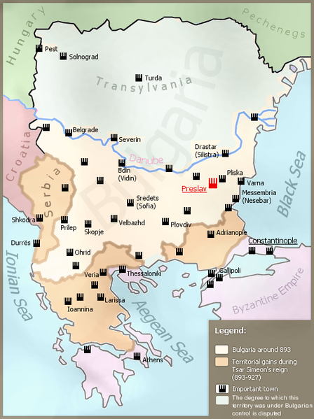
|
Posted By: Milos Obilic
Date Posted: 06-May-2006 at 19:41
 ------------- небески народ |
Posted By: erci
Date Posted: 06-May-2006 at 20:05
how did you cum up with that? 
------------- "When one hears such music, what can one say, but .... Salieri?" |
Posted By: Milos Obilic
Date Posted: 06-May-2006 at 20:25
|
just a historical map of Serbia's and Greece's territories that are now
being occupied by the Albanians (NORTHERN EPIRUS), 'Macedonians'
(territorially) (FYROM), Bulgarians (MACEDONIA), Turks(CYPRUS), and
bosnian muslims - islamized Serbs (BOSNIA)
------------- небески народ |
Posted By: GoldenBlood
Date Posted: 07-May-2006 at 03:58

|
Posted By: GoldenBlood
Date Posted: 07-May-2006 at 04:02
Albania 1912  |
Posted By: GoldenBlood
Date Posted: 07-May-2006 at 04:05
| . |
Posted By: akritas
Date Posted: 07-May-2006 at 05:09
|
GoldenBlood your maps are more closely in the known nationalistic maps that show the "Great Albania" ------------- 
|
Posted By: GoldenBlood
Date Posted: 08-May-2006 at 01:57
|
It is true Map look 1912 year go read history....now majority land of Albanians have been occupied from serbs, fyromians ect....all know there land were historical albanian land and there had (and today have) albanians. And look you Great Greece...like ultra nacionalist greeks...how south italy were greek land?
|
Posted By: Neoptolemos
Date Posted: 08-May-2006 at 04:01
Yeah, let me teach Akritas some history... Conference of London: End of First Balkan War Treaty of Bukarest: End of Second Balkan War Before the Balkan Wars no Albanian State  -------------
|
Posted By: akritas
Date Posted: 08-May-2006 at 10:19
South Italy is ITALY and not historical boundaries of the Balkans.Your maps is ultra-nationalistic maps and tottally un-accurate. Since when the Ottoman Empire named vilayets as Albanians ? Can you allocate the land that the neigboors countries supposed occupy from the "Great Albania"? not here please. Just open a new thread that consern your Historical boundaries.I will be glad to teach me history -------------
|

Posted By: ManOwaRadO
Date Posted: 15-May-2006 at 04:11
|
Very very funny |
Posted By: Milos Obilic
Date Posted: 16-May-2006 at 19:12
|
what's so funny? ------------- небески народ |
Posted By: bleda
Date Posted: 16-May-2006 at 19:20
|
you ------------- |
Posted By: Milos Obilic
Date Posted: 16-May-2006 at 19:26
|
ok, then could you rearrange my (just a histori...) sentence into another sentence which makes sense? ------------- небески народ |
Posted By: ManOwaRadO
Date Posted: 17-May-2006 at 07:37
|
I also can give you a map of Bulgaria from ІX - X c. (Simeon the Great) where its territory is about 600 000 km2 and tell you "just a historical map of Bulgaria's territories that are now being occupied by Romania, Serbia, Greece, FYROM, Turkey"... |
Posted By: Digenis
Date Posted: 22-May-2006 at 13:55
|
Milos Obilic got his ban,for his nationalistiic attitude. I wonder when all the nationalists by all sides,will get a single warning. @Goldenblood. There werent any Albanian,or Greek or Bulgarian Villaets in Ottoman empire. Villaets were an administrative geographical region and had nothing to do with ethnicity. As for 1912 Albania-there was never such a thing existed-u can hardly read the "www.shqiperia....org nationalistic sites were the mpas were taken from. This great albania lives only in the sick minds of nationalists. (as great greece,great serbia ,bulgaria etc) ------------- |
Posted By: Theodore Felix
Date Posted: 24-May-2006 at 23:12

Man they should call you the map master. Finally this puts things into perspective..
As for milos. Banned so fast? Jeez this place is really losing its patience on nationalists. Cant blame em ------------- |
Posted By: tsar
Date Posted: 28-May-2006 at 18:55
| we need chargemaster and his maps :) |
Posted By: akritas
Date Posted: 26-Jun-2006 at 13:19
|
Intesting racial map that show the South Balkans and particuraly the Greek and Turkish population before the Convention of the Exchange(1923). Is from Beeley and his essay "The Greek-Turkish Boundary Conflict at the Interface" Personnaly I beleive that this map is accurate.  -------------
|
Posted By: greco
Date Posted: 27-Jun-2006 at 07:54
|
http://foreignaffairs.tripod.com/armillotta/mappa52.html - http://foreignaffairs.tripod.com/armillotta/mappa52.html http://www.cslab.ece.ntua.gr/~phib/images/maps/history/MegaliHellas.jpg - http://www.cslab.ece.ntua.gr/~phib/images/maps/history/MegaliHellas.jpg http://academic.evergreen.edu/g/grossmaz/20thCentRomania.jpg - http://academic.evergreen.edu/g/grossmaz/20thCentRomania.jpg http://academic.evergreen.edu/g/grossmaz/20thCentBulgaria.jpg - http://academic.evergreen.edu/g/grossmaz/20thCentBulgaria.jpg http://academic.evergreen.edu/g/grossmaz/Balkans1910Ethnic.jpg - http://academic.evergreen.edu/g/grossmaz/Balkans1910Ethnic.jpg http://academic.evergreen.edu/g/grossmaz/Yugoslavia1941.jpg - http://academic.evergreen.edu/g/grossmaz/Yugoslavia1941.jpg
|
Posted By: greco
Date Posted: 27-Jun-2006 at 07:57
|
http://northerniraq.info/maps/albums/userpics/10002/normal_kurdistanmap.jpg - http://northerniraq.info/maps/albums/userpics/10002/normal_kurdistanmap.jpg
the futur
|
Posted By: greco
Date Posted: 27-Jun-2006 at 08:01
| http://www.imninalu.net/Myths_files/Vlach-expansion.jpg - http://www.imninalu.net/Myths_files/Vlach-expansion.jpg |
Posted By: greco
Date Posted: 27-Jun-2006 at 08:02
|
http://www.dunav.org.il/images/maps/greek%20regions/map_greece_vlach.jpg - http://www.dunav.org.il/images/maps/greek%20regions/map_greece_vlach.jpg
Map of Vlachs in Greece
|