Notice: This is the official website of the All Empires History Community (Reg. 10 Feb 2002)


Game Designers here? |
Post Reply 
|
Page <12 |
| Author |
 Printable Version Printable Version Google Google Delicious Delicious Digg Digg StumbleUpon StumbleUpon Windows Live Windows Live Yahoo Bookmarks Yahoo Bookmarks reddit reddit Facebook Facebook MySpace MySpace Newsvine Newsvine Furl Furl Topic Search Topic Search  Topic Options Topic Options
|
Maju 
King 

Joined: 14-Jul-2005 Online Status: Offline Posts: 6565 |
 Quote Reply Quote Reply
 Topic: Game Designers here? Topic: Game Designers here?Posted: 01-Nov-2005 at 13:41 |
|
I used the following maps as bases (I've lost track of their source in most cases):
This one for post-Roman Britain (which is pretty precise):   For the Anglo-Saxon kingdoms, I used more vague references and adapted them to the previous map. Some of the maps used were:  Here you can see how the space named Jutes (Meonwara) is very accurately coincident with where I put it in. Yet this map doesn't show all the minor states, like Lindsey, Hwicca and Mid Anglia, so take this one (from Wikipedia) also as reference: 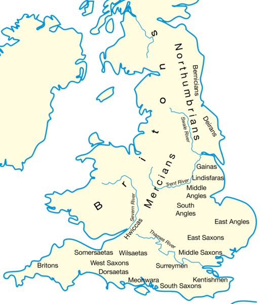 Obviously, I also read something about the period, in Wikipedia and other sources. But I can't find some of them  . .Anyhow I would be unable to say what's the diference between a modern English name and an Anglo-Saxon one. Wasn't London always London? Didn't Anglo-Saxons speak English? Just ranting. Actually your apportations on old names for both Gaelic anc Anglo-Saxon cities are most welcomed and I would like to end with a throughout list of historical names for all them and hopefully also the best places for the cities (centers) - though they don't have to be cities anyhow: counties and provinces were in the Middle Ages as important, so if only London and York survive as cities-centers and the rest are rather territories, I think it could be fine. I take note of your interesting apportations. Thanks a lot.  |
|

NO GOD, NO MASTER! |
|
 |
|
|
Bishop
Shogun 

Joined: 08-Jun-2005 Location: United States Online Status: Offline Posts: 223 |
Quote Reply
Posted: 30-Nov-2005 at 19:02 |
|
Wow Maju these are some of the best varents ive seen!
I know a good deal of history, and im a strategy war game nut. If you need any help testing and balancing you're maps let me know. You should put them up for test runs and debugging on the forum. Im sure you can get enough people to play/test the maps. |
|
|
The road to hell is paved with good intentions.
|
|
|
|
|
Post Reply
|
Page <12 |
| Forum Jump | Forum Permissions You cannot post new topics in this forum You cannot reply to topics in this forum You cannot delete your posts in this forum You cannot edit your posts in this forum You cannot create polls in this forum You cannot vote in polls in this forum |
Bulletin Board Software by Web Wiz Forums® version 9.56a [Free Express Edition]
Copyright ©2001-2009 Web Wiz
This page was generated in 0.078 seconds.
Copyright ©2001-2009 Web Wiz
This page was generated in 0.078 seconds.