


Notice: This is the official website of the All Empires History Community (Reg. 10 Feb 2002)


Valley of Tuwa? |
Post Reply 
|
Page 12> |
| Author |
 Printable Version Printable Version Google Google Delicious Delicious Digg Digg StumbleUpon StumbleUpon Windows Live Windows Live Yahoo Bookmarks Yahoo Bookmarks reddit reddit Facebook Facebook MySpace MySpace Newsvine Newsvine Furl Furl Topic Search Topic Search  Topic Options Topic Options
|
anum 
Knight 
Joined: 14-Dec-2007 Online Status: Offline Posts: 92 |
 Quote Reply Quote Reply
 Topic: Valley of Tuwa? Topic: Valley of Tuwa?Posted: 26-Dec-2007 at 17:21 |
|
I have a question does any one know where valley of Tuwa is located in Saudi Arabia?
|
|
 |
|
|
Guests
Guest 
|
Quote Reply
Posted: 01-Jan-2008 at 00:04 |
|
I looked at Ptolemy's Geography which dates to the year 150 AD. He doesn't mention it.
Do you have a time frame for this name?
|
|
|
|
|
anum
Knight
Joined: 14-Dec-2007 Online Status: Offline Posts: 92 |
Quote Reply
Posted: 01-Jan-2008 at 17:30 |
|
well in the quran it mentions that valley of tuwa is located near Mt.Sinai. and it is a sacred valley. I was wondering is it still a sacred valley? and does anyone know the location?
|
|
|
|
|
Guests
Guest
|
Quote Reply
Posted: 23-Jun-2008 at 13:01 |
|
From little snooping around it all points to Damascus as the location. and is it still sacred? I suppose how religious you are, I would say it is historical site for sure. |
|
|
|
|
azimuth
Caliph 

SlaYer'S SlaYer Joined: 12-Dec-2004 Location: Neutral Zone Online Status: Offline Posts: 2979 |
Quote Reply
Posted: 24-Jun-2008 at 16:36 |
can you please post where it tells that Vally of Tuwa in Damascus? from my search Tuwa mentioned in the Holy Quran twice Verse 79:16 (Behold, thy Lord did call to him in the sacred valley of Tuwa) Verse 20:12 (Verily I am thy Lord! therefore (in My presence) put off thy shoes: thou art in the sacred valley Tuwa.) its a vally between Madina and Egypt . also many scholars mentioned that the Word Tuwa means Twice, as the vally which was scared/holy twice but it looks like the name of the vally is more accurate that the other meaning. and its the place where God talked to Prophet Mosa. where he saw a fire and where his wood stick became like a snake. |
|

|
|
|
|
|
Guests
Guest
|
Quote Reply
Posted: 25-Jun-2008 at 11:41 |
|
The article which i was refering to canbe found at this location.
|
|
|
|
|
azimuth
Caliph
SlaYer'S SlaYer Joined: 12-Dec-2004 Location: Neutral Zone Online Status: Offline Posts: 2979 |
Quote Reply
Posted: 26-Jun-2008 at 12:37 |
|
your source say
there is an obvious contradiction here
i dont understand how mout sinai was located in Damascus?!!!!!! and why they say it WAS?!!
and Damascus is not between Madyan and Egypt, Madyan is located north West of the Arabian peninsula close to al Aqaba in Jordan i think and of course Egypt is more to the west of it.
i think who wrote that tafseer (explanation) mixed up between Sham as in Damascus and Sham as in Jordan, Palestine, Lebanon and Syria.
|
|
|
|
|
|
|
|
Qamar Ariff
Immortal Guard 
Joined: 27-Nov-2008 Online Status: Offline Posts: 9 |
Quote Reply
Posted: 27-Nov-2008 at 16:01 |
|
Assalamualaikum,
The sacred valley of Tuwa as mentioned in the Quran is located at Jabal Al Lawz in Madyan, North West of the Saudi peninsular. Google up the real mount sinai or look it up in youtube and there are many articles on it. It is a potential religious and political time bomb as this area is sacred to the muslims, jews and christian and is also close to the site of a Saudi air force base. They also apparently found the site where Nabi Musa crossed the Red Sea from Nuweibah to Madyan where there is said to be an underwater land bridge beneath the gulf of Aqabah. Apparently they had sent ROVs to dive along the underwater land bridge and found coral formation in the shape of chariot wheels . At the valley itself they found a manmade alter with drawings of Egyptian Apis Bull. There is a documentary movie coming up in early next year but of course, since its been done by the yahud, will place blame on Muslims for trying to conceal this site. The movie is called the Exodus Conspiracy - www.exodusconspiracy.com Salam, Qamar Ariff |
|
|
|
|
Guests
Guest
|
Quote Reply
Posted: 07-Dec-2008 at 20:12 |
|
^ thanks for the info bro, I will be moving to saudi arabia next year for work and inshallah i will visit all these historical places. History, specially religious history is my passion.
|
|
|
|
|
Qamar Ariff
Immortal Guard
Joined: 27-Nov-2008 Online Status: Offline Posts: 9 |
Quote Reply
Posted: 08-Dec-2008 at 15:03 |
|
another important clue to the location is the prophets isra or night journey. The angel gabriel had asked the prophet to pray at 5 locations. These location must have been sacred. One mecca, two madinah, three tur sinar, four bait laham aka bethelehem and fifth baitul maqdis. The valley of tuwa where moses first met god was at mount tur sinar and if you follow the order, it must have been between bethlehem and madinah. I would love th have the chance to go there
|
|
|
|
|
azimuth
Caliph
SlaYer'S SlaYer Joined: 12-Dec-2004 Location: Neutral Zone Online Status: Offline Posts: 2979 |
Quote Reply
Posted: 11-Dec-2008 at 06:29 |
|
that jabal al lowz theory is not scientific and there has not been any real research regarding it, and i think saudi arabia closed the site so it wont have christian pilgrimage wondering around in saudi desert, a safety matter.
|
|
|
|
|
|
|
|
Qamar Ariff
Immortal Guard
Joined: 27-Nov-2008 Online Status: Offline Posts: 9 |
Quote Reply
Posted: 07-Feb-2009 at 00:58 |
|
Assalamualaikum,
For more information on the potential site, look it up under google earth. There are some markers that point certain historical site in the valley below Jabal Al Lawz aka Mount Tur Sinar. See the actual photos of these sites and the fenced up area surrounding the "golden calf" alter. There is a reason why god has revealed the location of the site now. According to hadith of our prophet SAW, this is also the site of the final battle where Nabi Isa seeks refuge from Ya'juj Ma'juj, hence it is sacred and important to us.
|
|
|
|
|
azimuth
Caliph
SlaYer'S SlaYer Joined: 12-Dec-2004 Location: Neutral Zone Online Status: Offline Posts: 2979 |
Quote Reply
Posted: 11-Feb-2009 at 11:32 |
|
well still its a theory, and as far as i know there has not been a research done by�professional��archeologists, �you might find similar clues in Sinai�peninsula�too.�
|
|
|
|
|
|
|
|
Qamar Ariff
Immortal Guard
Joined: 27-Nov-2008 Online Status: Offline Posts: 9 |
Quote Reply
Posted: 22-Mar-2009 at 08:01 |
|
Salam
Maybe the following articles and photos may satisfy your scientific curiosity.
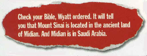
Above - Vanity Fair Magazine published a large article on the discovery of this mountain in the February 1998, issue, and featured many photos. Unfortunately the article centers around two gentlemen who came along after Ron Wyatt, but are claiming to have found the mountain. Mr. Wyatt told David Fasold about the discovery who then told the two men who went out in 1988, to see the mountain. Ron was on CBS News in 1984, telling about his trip to see the mountain and what he found there. He had entered the country without a visa and was thought to be a spy. He nearly died in prison there. Here the magazine quotes Ron Wyatt:
Bible Texts Locate the Real Mount Sinai
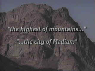
Josephus Said It Was the Highest Mountain
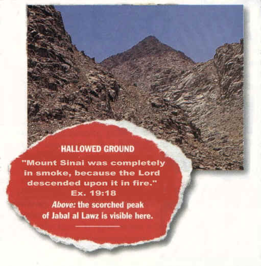
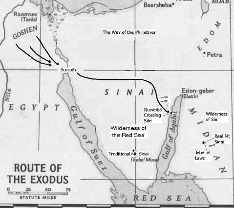
Josephus said that Mt. Sinai "was the highest of mountains in the city of Madian" which is just outside the town of Al Bad. Jebel el Lawz is the highest mountain in the upper two thirds of the country. Also, Philo said Mt. Sinai was located east of the Sinai Peninsula and south of Palestine.
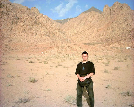
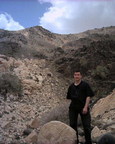
Above - Aaron Sen stands in the encampment area of Mt. Sinai with the blackened peak in the distance. www.wyattarchaeology.com
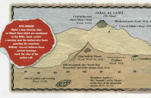
Layout of Mountain & Artifacts
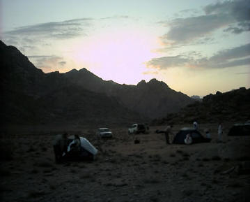
Mr. Wyatt is the original modern-day discoverer of the real Mount Sinai. The upper 200 feet of Jebel el Lawz is burned black, as we have seen in previous photos above. The Saudi Government will confiscate any photographs of the mountain and will not allow any tourists into the country, but U.S. Government satellite photos and a few private photos smuggled out of the country reveal the secret mountain by its unique blackened peak. Unlike the traditional site, there are thousands of acres in which to encamp at the base of this mountain, while clearly being visible from the mountain top. The Altar of the Golden Calf
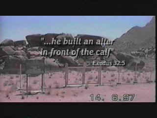
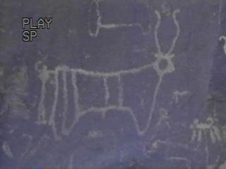
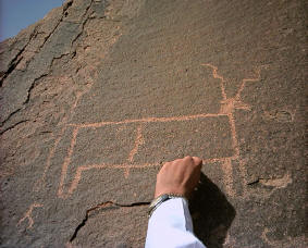
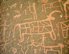
Above left - A dozen giant boulders are stacked in the encampment area and reveal 12 ancient Egyptian petroglyphs of bulls. It is believed the golden calf was placed upon these rocks. Large altars are found on the east and west sides of the mountain. (two upper photos Viveka Ponten) (two lower photos courtesy Aaron Sen
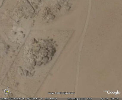
Above: Using Google Earth you can see the fence around these large rocks, out in the encampment area. Government Acknowledges Archaeological Significance
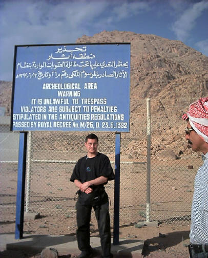
After Mr Wyatt found this site in 1984, and visited it again a year later, the Saudi government erected a fence and a guard house preventing access to the Holy Precinct area at the foot of the mountain on the eastern side. The sign above states, "Archaeological area...unlawful to trespass, subject to penalty." When Ron and his two sons made their fist trip into Saudi Arabia, they were accused of being spies and were held prisoner for two months, awaiting execution. After Ron helped to heal many sick prisoners, the authorities listened to his story and accompanied him to the column at the Saudi beach, then to Mt. Sinai. It was then they believed him, but they had to confiscate his photographs before letting him go.
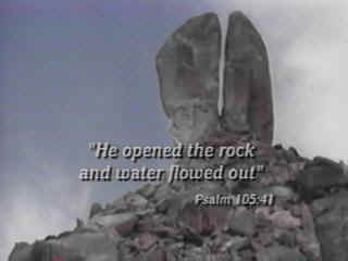
The Rock which Flowed Forth Water
On the western or back side of the mountain is Rephidim where Moses and the Children of Israel first encamped before reaching Mt. Sinai. It was here that Moses struck the rock, above, which gushed forth large quantities of water. The giant 60 foot rock is on a 300 foot tall hill, and has obvious signs of water erosion, yet it is located in this desert region. The fissure in the rock is so large that you can walk easily through it. A square 20 foot altar is also at this site, which was built after the Children of Israel defeated the Amalakites. The Amalakite territory covered "south of Judah and probably extended into northern Arabia" Britanica.
Some Television Coverage Hershel Shanks, editor of Biblical Archaeology Review was quoted in Newsweek that "Jebel el Lawz is the most likely site for Mount Sinai." Dateline NBC has featured Jebel el Lawz in one of its reports. |
|
|
|
|
Qamar Ariff
Immortal Guard
Joined: 27-Nov-2008 Online Status: Offline Posts: 9 |
Quote Reply
Posted: 22-Mar-2009 at 08:03 |
|
And this taken from the exodus conspiracy website
Tuesday, December 23, 2008The Lost Sea of the ExodusDr. Glen Fritz has done pioneering work in locating the sea that the Israelites crossed during their exodus from Egypt. Known as Yam Suph in the ancient Hebrew manuscripts, the name of this sea was changed to Red Sea in the Septuagint, which was the first translation of the Tanakh or Old Testament into another language - Greek. The name Red Sea was retained in all subsequent translations and the original meaning and location of Yam Suph faded from memory, becoming one of the greatest mysteries of the Bible. Over the past centuries, the academic community has gravitated toward associating suph with the Egyptian word twfy or tjuf, which means papyrus. This led them to postulate the meaning of Yam Suph as sea of reeds rather than Red Sea and since the Red Sea did not contain papyrus, scholars have proposed crossing points at various reed lakes and marshes near the border of Egypt. As a geographer, Dr. Fritz has used a unique approach to pinpoint Yam Suph in a region far from the traditional sites. In his recent book, The Lost Sea of the Exodus, Dr. Fritz puts forward the idea of a crossing at Nuweiba Beach on the coast of the Gulf of Aqaba and crossing over to ancient Midian located in present day northwest Saudi Arabia. Dr. Fritz has granted us a phone interview where we discussed his important findings. The following post contains segments from that interview with Exodus team member, Steve Law.  Dr. Glen A. Fritz, Author of The Lost Sea of the Exodus SL: What flaws did you see in some of the traditional theories about the crossing site that led you to seek new answers?  The Exodus Region SL: As a geographer, what was your approach to trying to solve the problem of finding where this sea is?  Director, Tim Mahoney and Lennart Moller at the Gulf of Aqaba SL: What do you see as the best biblical evidence that points to Yam Suph being the Gulf of Aqaba?  The Red Sea According to the Chart of Agnese Battista, ca.1544. This map is typical of Red Sea representations prior to the 19th century. (Library of Congress) SL: Why hasn’t Yam Suph as the Gulf of Aqaba been considered as a dominant theory in the past? |
|
|
|
|
Goocheslamb
Housecarl 
Joined: 16-Feb-2009 Online Status: Offline Posts: 40 |
Quote Reply
Posted: 22-Mar-2009 at 17:16 |
|
one thing i dont understand is why most people dismiss and are not interested in this location? clearly this location is so much better then the Mt.Sinai in egypt
also one thing, how was Aaron sen allowed over there? isn't he jewish?
|
|
|
|
|
Qamar Ariff
Immortal Guard
Joined: 27-Nov-2008 Online Status: Offline Posts: 9 |
Quote Reply
Posted: 24-Mar-2009 at 03:25 |
|
Salam, to be honest, i would love to visit this site. If not for anything to verify the finding and make an islamic story rather than just taking the jewish or christion version. I am quite sad that we have to wait for a non muslim to point it out. If you go to the exodus conspiracy website you can obvious see the political connotation in that they blame the muslims for supressing and destroying evidence.
|
|
|
|
|
Omar al Hashim
King 
Suspended Joined: 05-Jan-2006 Online Status: Offline Posts: 5697 |
Quote Reply
Posted: 24-Mar-2009 at 06:30 |
 , yeah, like the Gulf of Aqaba lay undiscovered for thousands of years. Sneaky bastard, hiding from all the people traveling on it, around it, and living nearby. , yeah, like the Gulf of Aqaba lay undiscovered for thousands of years. Sneaky bastard, hiding from all the people traveling on it, around it, and living nearby.Your going to have to find some better evidence Qamar.
|
|
|
|
|
Qamar Ariff
Immortal Guard
Joined: 27-Nov-2008 Online Status: Offline Posts: 9 |
Quote Reply
Posted: 24-Mar-2009 at 13:26 |
|
i suppose, mt sinai on the sinai peninsular which was founded only 325ad based on the dream of queen helena, the mother of the emperor constantine is a better location?
|
|
|
|
|
Omar al Hashim
King
Suspended Joined: 05-Jan-2006 Online Status: Offline Posts: 5697 |
Quote Reply
Posted: 24-Mar-2009 at 23:41 |
|
Probably not, but that doesn't help the case of Jabal al Lawz.
|
|
|
|


")
|
Post Reply
|
Page 12> |
| Forum Jump | Forum Permissions You cannot post new topics in this forum You cannot reply to topics in this forum You cannot delete your posts in this forum You cannot edit your posts in this forum You cannot create polls in this forum You cannot vote in polls in this forum |
Copyright ©2001-2009 Web Wiz
This page was generated in 0.047 seconds.

